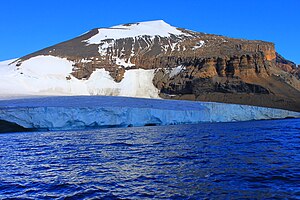
Brown bluff
| Brown bluff | ||
|---|---|---|
|
View from Antarctic Sound to Brown Bluff |
||
| height | 745 m | |
| location | Tabarin Peninsula , Antarctica | |
| Dominance | 15.52 km → Mount Taylor | |
| Coordinates | 63 ° 31 '57 " S , 56 ° 55' 32" W | |
|
|
||
| Type | Tabular volcano | |
| rock | Hyaloclastite , tuff | |
|
North flank |
||
Brown Bluff is a tabular volcano near the northern tip of the Antarctic Peninsula and the highest mountain on the Tabarin Peninsula .
geography
Brown Bluff is located on the east coast of the Tabarin Peninsula on the Antarctic Sound , about 13 km southeast of Hope Bay and 8 km west of Jonassen Island . The name (as much as "brown cliff") describes the appearance of the mountain from the sea side. The north flank is largely ice-free and red-brown in color. The 745 m high Brown Bluff is about a million years old and has the typical shape of a tabular volcano with steep walls and a flat plateau, which suggests that the lava emerged under a glacier or ice sheet .
Flora and fauna
The stone and ash beach at the foot of Brown Bluff and the snow-free part of the cliff are designated by BirdLife International as an Important Bird Area (AQ073). There is one colony of Adelie penguins (about 20,000 breeding pairs) and one of Gentoo penguins (about 550 breeding pairs). Dominican gulls , Cape petrels , snow petrels and skuas , probably also spotted petrels , giant petrels and silver petrels breed here . At mammals are regularly Weddell seals observed on the beach. Leopard seals hunt in the waters off the coast.
The vegetation is sparse. Lichen of the genera Xanthoria and Caloplaca grow on boulders of the beach and the cliff up to a height of 185 m. Mosses can still be found in higher regions .
tourism
Brown Bluff is regularly visited by tourists. The shore leave is strictly regulated by the Antarctic Treaty for nature conservation reasons.
On the evening of December 28, 2007, an incident occurred in the waters off Brown Bluff. The Norwegian cruise ship Fram of the shipping company Hurtigruten ASA collided with an iceberg after an engine failure and was damaged on the outer skin. Despite this damage, the ship was able to call at the nearest berth of a Chilean military base on King George Island on its own . Passengers were not harmed in the accident.
Web links
- Tabarin Peninsula in the Global Volcanism Program of the Smithsonian Institution (English).
Individual evidence
- ↑ a b c Brown Bluff (AQ073) , datasheet on the BirdLife International website, accessed July 23, 2018.
- ↑ Brown Bluff on Peakbagger.com (English).
- ↑ Mary G. Chapman, Carlton C. Allen, Magnus T. Gudmundsson, Virginia C. Gulick, Sveinn P. Jakobsson, Baerbel K. Lucchitta, Ian P. Skilling, Richard B. Waitt: Volkanism and Ice Interactions on Earth and Mars. In: James R. Zimbelman , Tracy KP Gregg (Ed.): Environmental Effects on Volcanic Eruptions. From Deep Oceans to Deep Space. Kluwer Academic / Plenum Publishers, New York 2000, ISBN 0-306-46233-8 , pp. 50-55 (English, limited preview in Google book search).
- ^ John L. Smellie et al .: The Cape Purvis volcano, Dundee Island (northern Antarctic Peninsula): late Pleistocene age, eruptive processes and implications for a glacial palaeoenvironment . In: Antarctic Science . tape 18 , no. 3 , September 2006, ISSN 0954-1020 , p. 399-408 , doi : 10.1017 / S0954102006000447 (English).
- ^ A b Antarctic Treaty Visitor Site Guide: 13. Brown Bluff. (PDF; 2.01 MB) In: ATS - Site Guidelines for visitors. Secretariat of the Antarctic Treaty, accessed August 24, 2017 .
- ↑ Kolliderte med isfjell. In: Bergens Tidende . December 29, 2007. Retrieved March 19, 2017 (Norwegian).


