
Bullerbach (Südaue)
| Bullerbach | ||
 On the upper reaches of the Bullerbach |
||
| Data | ||
| Water code | DE : 488862 | |
| location | Barsinghausen , Hanover region | |
| River system | Weser | |
| Drain over | Südaue → Westaue → Leine → Aller → Weser → North Sea | |
| source | In the Deister west of Barsinghausen 52 ° 17 ′ 25 ″ N , 9 ° 25 ′ 6 ″ E |
|
| Source height | approx. 320 m | |
| muzzle | on the eastern edge of Barsinghausen- Großgoltern in the Südaue coordinates: 52 ° 20 ′ 20 ″ N , 9 ° 30 ′ 25 ″ E 52 ° 20 ′ 20 ″ N , 9 ° 30 ′ 25 ″ E |
|
| Mouth height | 55 m | |
| Height difference | approx. 265 m | |
| Bottom slope | approx. 31 ‰ | |
| length | 8.4 km | |
| Catchment area | 22.3 km² | |
| Right tributaries | Fuchsbach , Reitbach | |
 At the Bullerbach it has become quiet over the decades |
||
The Bullerbach is about 8.4 km long, orographic left and southwesterly inflow of Südaue at Nordgoltern in the city Barsinghausen in the Hanover region in Lower Saxony .
geography
The Bullerbach arises west of Barsinghausen in the Deister on the northern slope of the Großer Hals . It combines some small bodies of water and flows in a north-easterly direction to the outskirts of the Barsinghausen district, which is located directly on the Deister. It crosses the north-west of the village and in it the state roads L 391 and L 392 as well as the route of the Deisterbahn in sections with pipes. On the northern edge, the Bullerbach separates the Bahlsenwerk from the neighboring industrial park and then reaches the Feldmark. The Grimmsmühle is then on the left by the stream. Shortly thereafter, a ditch following the former middle course of the Fuchsbach flows into the Bullerbach, which shortly afterwards passes the geographical center of Barsinghausen, which is marked with a memorial stone and a refuge. To the southwest of Großgoltern, the Reitbach flows into the Bullerbach from the south . Before the water regulations in the 20th century, this was the mouth of the Fuchsbach. The Bullerbach only flows on the western edge of Großgoltern and crosses the county road K241 on the border with Nordgoltern . In the northeast of the Großgoltern outdoor pool , the Bullerbach flows into the Südaue. Only the lower 4.8 kilometers of the course of the stream from the crossing of the Deisterbahn and the L392 fall under the jurisdiction of the responsible water maintenance association .
history
In the 19th century, Wealden coal was extracted from several tunnels and shafts in the Bullerbachtal . Later the production shifted to the Barsinghausen monastery tunnel and the shafts there. The Bullerbach shaft was used as a weather shaft until 1930 . The mine structures were demolished.
environment
The Bullerbach runs in the Deister in the landscape protection area LSG-H 23 Norddeister. Here it corresponds to the water type "fine material rich silicate low mountain range" (type 5.1).
The middle section initially runs in the town and then lined with occasional wooded sections in the tidy agricultural landscape. The last 200 m before the confluence with the Südaue are in the LSG-H 25 Benther Berg - Südaue nature reserve.
Water quality
The water quality of the upper reaches of the Bullerbach is classified in quality class I. The low water flow in the summer months makes an assessment according to the saprobic system difficult . Below the populated area of Barsinghausen, this is reduced to quality class II-III.
Sights and buildings
At the edge of the Deister forest in the Bullerbachtal is the Naturfreundehaus Barsinghausen, which is also operated as a restaurant. This is the starting point of an educational forest trail leading into the Deister, as well as one of several routes on the coal trail that lead to traces of mining in the area.
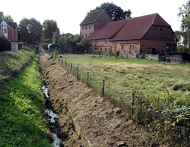
In the south of the district nor the Großgoltern than on Bullerbach monument protected building, built in 1681 and operated until 1956 watermill receive Grimm mill.
Of connected to the Bullerbach moats surrounding estates in Großgoltern and Nordgoltern are protected as monuments. The Kastanienallee to the west of the Großgoltern estate, protected as a natural monument , crosses the Bullerbach.
At the lower reaches of the Bullerbach in the districts of Großgoltern and Nordgoltern, there are two cenotaphs on Kreisstraße and the only remaining outdoor swimming pool in Barsinghausen. The outdoor swimming pool in the Barsinghausen district, also located on Bullerbach, was closed in the 1990s and later replaced by a supermarket.
- Views along the Bullerbach
The Bullerbach crosses Barsinghausen
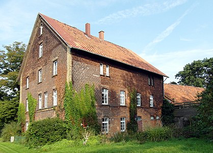
Grimmmühle
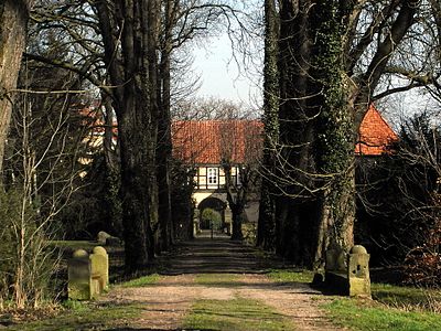
Bridge of the Kastanienallee over the Bullerbach at Gut Großgoltern


Web links
Individual evidence
- ↑ Topographic map of the source of the Bullerbach ( memento of the original from October 8, 2016 in the Internet Archive ) Info: The archive link was automatically inserted and not yet checked. Please check the original and archive link according to the instructions and then remove this notice. , accessed October 7, 2016 at natur-erleben.niedersachsen.de
- ↑ Topographic map of the mouth of the Bullerbach ( Memento of the original from October 8, 2016 in the Internet Archive ) Info: The archive link was inserted automatically and has not yet been checked. Please check the original and archive link according to the instructions and then remove this notice. , accessed October 7, 2016 at natur-erleben.niedersachsen.de
- ↑ List of waters. Retrieved October 7, 2016 .
- ^ Area directory for the Lower Saxony hydrographic map. (PDF; 599.8 KB) Update as of July 13, 2010. www.umwelt.niedersachsen.de, accessed on January 8, 2016 .
- ↑ List of waters. Entertainment association West and Südaue, accessed on October 7, 2016 .
- ↑ General entertainment plan . (pdf; 15.3 MB) Unterhaltungsverband West- und Südaue, accessed on October 7, 2016 .
- ↑ Landscape framework plan of the Hanover region. Status 2013. (pdf; 16.4 MB) Region Hannover. Environment department. Nature conservation team 36.04, 36.05 AG landscape framework plan, p. 127 , accessed on May 13, 2015 .
- ↑ Landscape framework plan of the Hanover region. Status 2013. (pdf; 16.4 MB) Region Hannover. Environment department. Nature conservation team 36.04, 36.05 AG landscape framework plan, p. 137 , accessed on May 13, 2015 .
- ↑ Grand Goltern. www.barsinghausen.de, accessed on October 7, 2016 .