
Menburg Castle Stables
| Menburg Castle Stables | ||
|---|---|---|
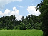
 Burgstall Menburg - view to the south |
||
| Creation time : | probably 11th century | |
| Castle type : | Höhenburg, spur location | |
| Conservation status: | Burgstall, remains of a moat | |
| Place: | Raisting - "Schlossberg" | |
| Geographical location | 47 ° 54 '24.3 " N , 11 ° 5' 5.6" E | |
| Height: | 570 m above sea level NN | |
|
||

The Burgstall Menburg refers to an abandoned high medieval hill castle at 570 m above sea level. NN in the spur of the Schlossberg west above the Michelbach and 2000 meters west of Raisting in the district of Weilheim-Schongau in Bavaria . The castle, mentioned in 1190, whose ownership has not been clarified, was probably built in the 11th century. In ancient writings, a “Pobowin von Raisting” and 1147 a “Gotebol de Raistingen” are mentioned in 1145, which suggests a count's seat of the Guelphs , presumably to control the road from Lech to Raisting. Today the site is registered as a ground monument D-1-8032-0073 "Burgstall of the high and late Middle Ages (" Menburg ")" by the Bavarian State Office for Monument Preservation .
An old Roman road from Epfach to Erling runs not far from the castle .
The castle stable of the former small section castle protected by the Michelbach in the east, south-east and north-east shows a depression on the castle plateau that suggests a round tower , in the west and south-west remains of moats and a ditch carved into the south slope.
View from the Raisting – Stillern road to the hill with the Burgstall (right half of the picture)
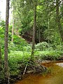
The Michelbach east below the former castle complex


Web links
- Menburg at geocaching.com
Individual evidence
- ^ Location of the Burgstall in the Bavaria Atlas
- ↑ List of monuments for Raisting (PDF) at the Bavarian State Office for Monument Preservation (PDF; 130 kB)


Palaces: Bernried Castle (now a monastery) | Höhenried Castle | Pähl Castle | Middle Castle Pähl (gone) | Lower Pähl Castle | Schongau Castle | Castle lakeside | Weilheim Castle (exited)
Castles and ruins: Peißenberg Castle (dismissed) | Peiting Castle (exited) | Willenberg Castle (exited)
Tower hill castles (all gone): Tower hill Mitterfischen | Sindelsdorf Tower Hill | Wilzhofen Castle
Manor houses: Hohenberg Castle
Castle stables (lost, unknown castles): section fortifications on the Stocket | Section fortification mountain | Section fortification mountain meadows | Burgstall Bernbeuren | Burgstall Burggen | Ringwall Burggen | Burgstall near Burgstall (Wessobrunn) | Burgstall Burklaberg (Alt-Schongau) | Burgstall Deutenhausen | Burgstall Eglfing | Burgstall Fußstain | Section fortification Gögerl | Burgstall Greut | Burgstall Iffeldorf | Burgstall Menburg | Burgstall Paterzell | Section fortification Paterzell | Burgstall Rameck | Burgstall Rossau | Burgstall Rothsee | Burgstall blow | Burgstall Schlossberg (Schongau) | Burgstall Schlossbichl | Burgstall Schneckenbichl | Burgstall Schwabbruck | Burgstall Sindelsdorf | Burgstall Sölb | Burgstall Tannenberg | Burgstall Wildsteig | Burgstall Zöpfhalden