Burgstrasse (Radebeul)
The Castle Road is a city road the Saxon town of Radebeul , situated in the district Niederlößnitz . The narrow, medieval Berggasse begins directly at the foot of the steep slope of the Lausitz Fault on the Obere Bergstrasse just east of the junction with Karlstrasse , leads past Bodelschwinghstrasse and crosses the steep ascent in a north-northeastern direction in a serpentine manner . It leads as a footpath west past the Friedensburg , from which the current name is derived, crosses the slope edge path Am Wasserturm and continues on the plateau of Oberkötzschenbroda as Obere Burgstrasse . The Finstere Gasse flows into it, while Obere Burgstrasse itself ends at Jägerhofstrasse.
Development
The steep Berggasse, which is signposted as a dead end street at the bottom of the mountain , is located in the major Saxon vineyard location Lößnitz within the individual vineyard Radebeuler Steinrücke , in the landscape conservation area Lößnitz and in the historic vineyard landscape in Radebeul . It rises from almost 140 m to about 208 m above sea level. NHN near Friedensburg, as Obere Burgstrasse it then falls back to 188 m above sea level until it joins Jägerhofstrasse . NHN from. For the 68 m ascent, Burgstrasse needs a distance of 440 m for a straight line 370 m.
The numbering begins in the valley; the odd numbers are on the left-hand west side, the even numbers opposite. When you change to Oberen Burgstrasse , the numbers continue.
Some cultural monuments are lined up along Burgstrasse and are therefore included in the list of cultural monuments in Radebeul-Niederlößnitz (A – L) and -Niederlößnitz (M – Z) :
- Burgstrasse: Badhotel Niederlößnitz (No. 2) , Villa Wartburg (No. 4) , Villa Vogelhaus (No. 5)
- Obere Burgstrasse: Friedensburg (No. 6)
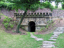
The Upper Castle Street ago passable from the upper land, while the Castle Road from below up to only about half the height above the Villa Wartburg is passable, to the plateau in front of the previously listed lower nozzle hole of the Gießmann's tunnel , a former irrigation tunnel through the mountain slope therethrough from Waldpark Radebeul-West . This should once supply the Badhotel with water.
Below the Villa Wartburg is one of Radebeul's underground water reservoirs.
In Gurlitt's 1904 inventory of monuments , sandstone figures from the first half of the 18th century are shown on the property of the Bad-Hotel (Burgstrasse 2, Obere Bergstrasse 62) written in this way.
Naming
The notch is a steep notch valley in the Lößnitz slopes , after which the vineyards to the west of it are also named Kerbenberge . At the same time, Kerbe is the name of the Berggasse, which is documented here in 1786 for the route to the highlands. Around 1600, the cartographer Matthias Oeder also used the term butt notch .
For the year 1874, the use of Steinigtweg for the Berggasse itself is documented, a name that today's Karlstraße , which leads from the Unterland to the mountain ascent, had as early as 1600. While the name Carlstraße for the connecting Karlstraße came from one of its residents from 1880 , the Berggasse kept the name Steinigtweg until 1905, when it was officially rededicated to the name Burgstraße after the adjacent Friedensburg mountain restaurant .
The section above the slope edge was given a name affix in 1934 and was rededicated in Obere Burgstraße ; both parts are connected by a steep climb that can be walked on.
literature
- Volker Helas (arrangement): City of Radebeul . Ed .: State Office for Monument Preservation Saxony, Large District Town Radebeul (= Monument Topography Federal Republic of Germany . Monuments in Saxony ). SAX-Verlag, Beucha 2007, ISBN 978-3-86729-004-3 .
Web links
- City map Niederlößnitz around 1924
- Manfred Richter: Burgstrasse. In: Niederlößnitz from yesteryear. Retrieved January 31, 2015 .
Individual evidence
- ↑ Barbara Bechter, Wiebke Fastenrath u. a. (Ed.): Handbook of German Art Monuments , Saxony I, Dresden District . Deutscher Kunstverlag, Munich 1996, ISBN 3-422-03043-3 , p. 730–739 (building mentioned as an example).
- ^ Manfred Richter: Burgstrasse. In: Niederlößnitz from yesteryear. Retrieved January 31, 2015 .
Coordinates: 51 ° 6 ′ 55 " N , 13 ° 38 ′ 10.3" E


