Calatagan
| Municipality of Calatagan | ||
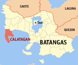
| Location of Calatagan in Batangas Province | ||
|---|---|---|

|
||
| Basic data | ||
| Region : | CALABARZON | |
| Province : | Batangas | |
| Barangays : | 25th | |
| District: | 1. District of Batangas | |
| PSGC : | 041008000 | |
| Income class : | 3rd income bracket | |
| Households : | 9201 May 1, 2000 census
|
|
| Population : | 56,449 August 1, 2015 census
|
|
| Coordinates : | 13 ° 50 ′ N , 120 ° 38 ′ E | |
| Geographical location in the Philippines | ||
|
|
||
Calatagan is a Filipino municipality in Batangas Province .
geography
The borough comprises the Calatagan Peninsula between the South China Sea and Balayan Bay . The peninsula's white beaches are popular recreation areas for the rich and famous of Manila . Calatagan is at the western exit of Isla Verde Street . This is considered a hotspot of biodiversity in the underwater world in the Philippines and worldwide.
archeology
One of the extremely rare finds of characters from pre-Hispanic times in the Philippines was made in Calatagan. The characters, called Baybayin in the Tagalog , were found on a burial urn from the 13th or 14th century.
Barangays
Calatagan is politically divided into 25 barangays .
|
|
