Rosario (Batangas)
| Municipality of Rosario | ||
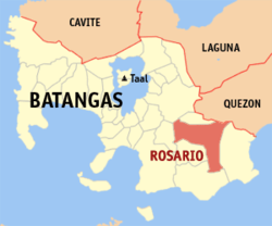
| Location of Rosario in the Batangas Province | ||
|---|---|---|

|
||
| Basic data | ||
| Region : | CALABARZON | |
| Province : | Batangas | |
| Barangays : | 48 | |
| District: | 4. District of Batangas | |
| PSGC : | 041021000 | |
| Income class : | 1st income bracket | |
| Households : |
May 1, 2000 census
|
|
| Population : | 116,764 August 1, 2015 census
|
|
| Population density : | 514.7 inhabitants per km² | |
| Area : | 226.88 km² | |
| Coordinates : | 13 ° 51 ′ N , 121 ° 12 ′ E | |
| Postal code : | 4225 | |
| Geographical location in the Philippines | ||
|
|
||
Rosario ( Tagalog : Bayan ng Rosario) is a Filipino municipality in the province of Batangas , in the administrative region IV, Calabarzon. It has 116,764 inhabitants (August 1, 2015 census) who lived in 48 barangays . It is classified as the first income class community in the Philippines and as urbanized .
The topography of the municipality is characterized by mountainous terrain. Their neighboring communities are San Juan in the east, Padre Garcia in the north, Lobo and Taysan in the south, and Ibaan in the west.
Barangays
|
|
|
