California State Route 78

|
|
|---|---|
| map | |

|
|
| Basic data | |
| Overall length: | 192 mi / 309 km |
| Opening: | 1934 |
| Starting point: |
|
| End point: |
|
| Counties: |
San Diego County Imperial County Riverside County |
| Important cities: |
Escondido Ramona Santa Ysabel Julian Brawley |
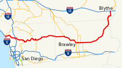
The California State Route 78 (abbreviated CA 78 ) is a state highway in the US state of California , which runs east-west direction. Its length is 309 kilometers.
The State Route begins on Interstate 5 at Oceanside and ends at Blythe on Interstate 10 .
course
From Oceanside to the intersection with Interstate 15 at Escondido , the CA 78 has been developed as a freeway that is comparable to the European motorways. The next major place the State Route passes through is Ramona , which is home to the largest zoological facility in the world, the San Diego Zoo Safari Park . In Ramona, the highway also meets California State Route 67 . Near Julian , CA 78 passes California State Route 79 . It runs through the Anza-Borrego Desert State Park between Julian and Ocotillo Wells .
In the south of the Salton Sea , California State Route 86 begins to use the CA 78 route. They split up again in the town of Brawley . In the urban area it also meets California State Route 111 and to the east on California State Route 115 . East of Brawley the road runs in a large arc, first in an easterly direction, then in a northerly direction. Between Palo Verde and Blythe, it runs parallel to the border with Arizona.
SR 78 east of Escondido
SR 78 in Anza-Borrego Desert State Park
See also
Web links
- California Highways (English)
- California @ AA Roads route description with photos


