Canning Stock Route
| Canning Stock Route | ||||||||||||||||||||||||||||
|---|---|---|---|---|---|---|---|---|---|---|---|---|---|---|---|---|---|---|---|---|---|---|---|---|---|---|---|---|
| map | ||||||||||||||||||||||||||||
| Basic data | ||||||||||||||||||||||||||||
| Operator: | Main Roads | |||||||||||||||||||||||||||
| Start of the street: |
Halls Creek ( WA ) ( 18 ° 19 ′ S , 127 ° 33 ′ E ) |
|||||||||||||||||||||||||||
| End of street: |
Wiluna ( WA ) ( 26 ° 36 ′ S , 120 ° 13 ′ E ) |
|||||||||||||||||||||||||||
| Overall length: | 1961 km | |||||||||||||||||||||||||||
|
States : |
||||||||||||||||||||||||||||
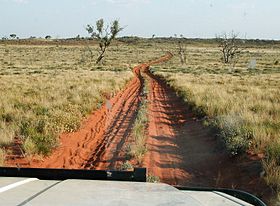
| Canning Stock Route in the Small Sand Desert | ||||||||||||||||||||||||||||
|
Course of the road
|
||||||||||||||||||||||||||||
The Canning Stock Route is an outback slope in the Australian state of Western Australia . Originally laid out as an old herd path that was used to drive cattle, it is now one of the toughest and most remote outback slopes in Australia. With a length of almost 2,000 km, it is also the longest. It connects the Great Northern Highway in Halls Creek in the Kimberley Region with the northern end of the Goldfields Highway in Wiluna , about 800 km northeast of the state capital Perth .
history
At the beginning of the 20th century, cattle breeders in the Kimberley region were looking for a quick and direct way to bring their cattle to the region around Perth. Alfred Canning laid out the route through the desert between 1906 and 1910 . Their course is based on the 52 wells that were built along the route. In order to be able to build these wells, Canning held some Aborigines prisoner and tortured them to tell him the location of natural water holes.
In the years that followed, the route was rarely used, due to its poor condition, but also to attacks by Aborigines. It was not until 1930 that the route was used regularly for its intended purpose and large herds of cattle were driven through the desert.
In 1968 the Canning Stock Route was driven for the first time in its entire length by an off-road vehicle . This laid the foundation for today's attractiveness of the route for adventurers and off-road fans.
course
The Canning Stock Route begins at Halls Creek, where it branches off the Great Northern Highway (N1). For the first 150 km it runs identically to Tanami Road in a southbound direction to Billiluna . On this first section, the route leads past the Wolfe Creek Meteorite Crater in the national park of the same name.
South of Billiluna, the Canning Stock Route runs in a south-westerly direction and crosses the Great Sandy Desert . Numerous dunes are crossed, but also dried up rivers and lakes are crossed. In Kunawarritji , Wapet Road / Kidson Track and Jenkins Track join the Canning Stock Route. The Jenkins Track connects to the Gary Highway and Gary Junction Road .
Further south, the Canning Stock Route leads around Lake Disappointment , a large salt lake on the northern edge of the Little Sandy Desert . The piste then crosses the Little Sandy Desert in a south-westerly direction before it meets the Goldfields Highway (R ALT 94) at Wiluna and ends.
nature
The route leads through two deserts, around 1000 dunes have to be crossed and, depending on the travel time, temperatures of 45 ° C and more prevail. For this reason, it is recommended to only use the route during the winter months. The route should only be driven with four-wheel drive vehicles , preferably in a convoy.
Careful planning is advisable before using the route, as there are only a few selected supply points along the way. While in the past fuel could only be pumped by hand from previously delivered barrels at one point, there has been an additional filling station for several years. The fuel must be ordered in advance for both fueling options.
Canning Stock Route by Bike
In 2005 Jakub Postrzygacz was the first person to complete the route by bicycle completely alone. He only needed 33 days for this, otherwise all-wheel drive vehicles need around 14 days. The New Zealander of Polish descent conquered the route in the Australian spring with a Bush bike specially made for him: the thickly profiled wide tires enabled him to make good progress over the many sandy dunes and stony stretches. The self-made third trailer wheel made it possible to transport the urgently needed additional water supplies. His menu consisted mainly of astronaut food and water, most of which he obtained from the restored wells or fresh water sources. A GPS device and a compass made it easier for him to find his way around, and he had a satellite cell phone for emergencies. The only clothes he had with him were those that were worn, which provided sufficient protection from the sun and were climate-friendly, easy to care for and light.
fauna
Alexandras parakeets can be seen along the way , a medium-sized species of parakeet with strikingly contrasting plumage and very long tail feathers. The species belonging to the parakeets is strongly adapted to a life in desert regions.
Information sign near Wiluna (2009)
literature
- John Slee: Canning, Alfred Wernam (1860 - 1936) , Australian Dictionary of Biography, Online Edition, Australian National University, accessed online December 28, 2006, ISSN 1833-7538 , see [1]
- Stanton, Jenny (Ed.): The Australian Geographic book of the Canning Stock Route , Terry Hills, NSW: Australian Geographic Pty Ltd, 1998. ISBN 1-86276-800-5
- Jörg Becker, Andreas Hülsmann: Searching for traces - On the legendary Canning Stock Route through the outback of Australia . Heel Verlag, Königswinter 2005, ISBN 978-3-933385-32-1 .
source
Steve Parish: Australian Touring Atlas . Steve Parish Publishing. Archerfield QLD 2007. ISBN 978-1-74193-232-4 . Pp. 85 + 87 + 90
Individual evidence
- ↑ Canning Stock Route on www.ExplorerOz.com ( English ) Retrieved on April 13 of 2009.
- ↑ Jakub's homepage


