Cape au Moine (Montreux)
| Cape au Moine | ||
|---|---|---|
|
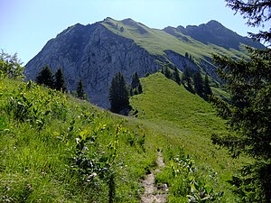
View of the Cape au Moine from the northwest. |
||
| height | 1941 m above sea level M. | |
| location | Canton of Friborg , Canton of Vaud ; Switzerland | |
| Mountains | Freiburg Pre-Alps | |
| Dominance | 1.5 km → Vanil des Artses | |
| Notch height | 81 m ↓ Col de Pierra-Perchia | |
| Coordinates | 564 690 / 146645 | |
|
|
||
| rock | Sedimentary rock | |
| Normal way | challenging alpine hiking | |
The Cape au Moine (German: Mönch sumhang) is a mountain in the Friborg Prealps on the border of the Swiss cantons of Vaud and Friborg .
location
The 1941 meter high summit lies between the valley of the Hongrin and the valley of the Baye de Montreux , which drains into the basin of Lake Geneva . The European main watershed runs along the north-south ridge on which the summit lies between the Vanil des Artses and the Dent de Jaman . The mountain dominates the Vaudois Riviera and offers a panoramic view over Lake Geneva.
rise
The summit can be reached via a demanding alpine hiking trail from the Col de Pierra-Perchia (1860 m) north of the summit . Four hiking trails lead there: from the Col de Jaman in the south along the western flank of the mountain, from Le Molard in the west over the Col de Soladier , and from the Allières and Les Cases stops on the Montreux – Lenk railway in Simmental to the east .
Web links
- Tours and photos of Cape au Moine at hikr.org
Individual evidence
- ↑ a b c d La Cape au Moine on the national map of Switzerland .
- ↑ Freiburg Pre-Alps at geofinder.ch

