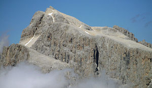
Cima di Vezzana
| Cima di Vezzana | ||
|---|---|---|
|
the west face of the Vezzana seen from the Rolle pass |
||
| height | 3192 m slm | |
| location | Belluno / Trentino , Italy | |
| Mountains | Dolomites , subgroup Pala group | |
| Dominance | 16.1 km → Punta Penia | |
| Notch height | 1274 m ↓ Passo San Pellegrino | |
| Coordinates | 46 ° 17 '24 " N , 11 ° 49' 50" E | |
|
|
||
| First ascent | June 23, 1878 by Douglas W. Freshfield and Charles C. Tucker | |
| Normal way | South ridge ( I ) | |
|
Vezzana from the south |
||
The Vezzana (also Cima della Vezzana or short Vezzana ) is 3192 m slm the highest elevation of Pala in the Italian Dolomites .
Location and surroundings
The mountain rises in the northern Pala group to the east above the Rolle Pass ( 1980 m ). It forms the border between the provinces of Trentino in the west and Belluno in the east. The Vezzana is separated from the Cimon della Pala ( 3184 m ) in the southwest by the Passo Travignolo ( 2925 m ) . The neighboring peak in the south is Il Nuvovo ( 3075 m ). In the north, the Passo di Val Strut ( 2870 m ) separates the Vezzana from the Cima dei Bureloni ( 3130 m ). While the eastern flank of the mountain is characterized by heaps of rubble, the Vezzana drops to the west with steep rock faces. Below the west walls is the Ghiacciaio del Travignolo, another small glacier . From Ghiacciaio di Val Strut , northeast of the Vezzana in Val Strut , only small firn fields have survived .
Bases and paths
The most important starting points for an ascent of the Vezzana are the Rolle Pass and San Martino di Castrozza in the west of the Pala group. To the northeast, the mountain is accessible from the village of Gares . The managed bases are the Baita Segantini ( 2170 m ) in the northwest and the Rifugio Rosetta ( 2581 m , cable car from San Martino) in the south . In addition, there are two bivouac boxes in the area of the mountain, the Bivacco Fiamme Gialle ( 3005 m ) on the Cimon della Pala and the Bivacco Giorgio Brunner ( 2667 m ) in the Val Strut.
In contrast to many other peaks in the Pala group, the Vezzana is not considered an important climbing mountain because of its fragile rock , but is mainly known for its two normal routes . One of these climbs leads as a marked path of difficulty I (UIAA) from Passo Travignolo to the summit. The easiest approach to the pass leads from the Rifugio Rosetta through the Val dei Cantoni , but it can also be reached via the Bolver-Lugli via ferrata ( difficulty C – D ) or from the north via the Travigno glacier. The second summit ascent leads from the east through the Val Strut to the Vezzana, with climbing points of difficulty I and the short via ferrata Gabitta D'Ignoti to be overcome. The Rifugio Rosetta or Gares are suitable starting points for this route.
In winter, the Vezzana can also be climbed as a ski tour . Possible ski slopes lead over the Travignoli glacier, through the Valle dei cantoni or through the Val Strut.
When the Cima di Vezzana was first climbed, the Cimon della Pala was still the highest peak of the Pala. The first to climb, Douglas W. Freshfield and Charles C. Tucker , did not yet know on June 23, 1878 that they were standing on the highest Pala peak. You reached the Vezzana from the Rolle Pass over the Travigno Glacier.
cards
- Compass hiking and ski tour map: Sheet 76 Pale di San Martino (1: 50,000). ISBN 978-3-85491-086-2
- Tobacco hiking map: Sheet 022 Pale di San Martino (1: 25,000). ISBN 978-88-8315-022-7
Web links
- Cima di Vezzana on tr3ntino.it (German, English, Italian)
- Cima della Vezzana on Summitpost.org
Individual evidence
- ↑ a b c Samuele Scalet u. a .: Pale di San Martino . Versante Sud, Milano 2002, p. 140 .
- ↑ Bolver-Lugli on klettersteig.de
- ↑ Gabitta D'Ignoti via ferrata on klettersteig.de
- ^ Tabacco hiking map: Sheet 022 Pale di San Martino (1: 25,000). ISBN 978-88-8315-022-7


