Pala group
| Pala | |
|---|---|
|
Pala group marked in red on the map of the Dolomites |
|
|
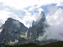
The Pale Group from the west, via San Martino di Castrozza |
|
| Highest peak | Cima di Vezzana ( 3192 m slm ) |
| location | Provinces of Belluno / Trient , Italy |
| part of | Dolomites |
| Coordinates | 46 ° 16 ′ N , 11 ° 52 ′ E |
| surface | 240 km² |
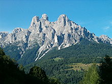
The Pala group ( Italian Pale di San Martino or Gruppo delle Pale ) is a Dolomite group in the border area of the Italian provinces of Belluno and Trento . The Trentino parts of the group belong to the Parco Naturale Paneveggio - Pale di San Martino . The Pale Group has been part of the Dolomites UNESCO World Heritage Site since 2009 .
location
The Pala group lies between the valleys of the Biois in the north, the Cordevole in the east and the Cismon in the southwest ( Primör ), in the northwest lies the Passo Rolle , in the north the Vallespass and southeast the Passo Cereda .
Characteristic
The Pala group is a climbing area with well-known climbing mountains , the peaks reach over three thousand meters . Rugged rock peaks like the Cimon della Pala contrast with the extensive plateau of the Altopiano delle Pale . The Dolomites high path No. 2 crosses the Pala from north to south from the Vallespass to Passo Cereda. Some of the most famous via ferratas in the Dolomites can be found in the Pala, such as B. the Via Ferrata Bolver-Lugli or the Via Ferrata Stella Alpina (Monte Agnèr). The ring around the Pala di San Martino goes around the central Pala from the Rif. Rosetta over the Passo di Ball to the Rif. Pradidali and back over the Passo Pradidali and the Altopiano delle Pale.
From San Martino di Castrozza , a cable car in two sections leads to the shoulder of the Cima Rosetta. The place is also known as a winter sports resort.
Well-known peaks
- Cima di Vezzana ( 3192 m ) - highest point of the Pala
- Cimon della Pala ( 3184 m ) - the "Matterhorn of the Dolomites" (famous view from the Rolle Pass )
- Cima Bureloni ( 3132 m )
- Cima Canali ( 2897 m )
- Pala di San Martino ( 2987 m )
- Cima Fradusta ( 2939 m ) - with a small glacier, can be climbed without climbing
- Cima Wilma ( 2782 m )
- Monte Mulaz ( 2906 m ) - in the northern part of the Pala, accessible without climbing
- Monte Agnèr ( 2871 m ) - famous for its northern edge (with an altitude difference of 1500 m, the highest climbing route in the Dolomites)
- Sass Maor ( 2814 m ) - climbing mountain
- Cima della Madonna ( 2733 m ) - famous climbing routes ("Schleierkante")
- Cima della Rosetta ( 2743 m ) - easily accessible by cable car from San Martino di Castrozza
Huts
- Rifugio Mulaz ( 2571 m , CAI ) - in the northern part of the Pala
- Rifugio Rosetta (also Rif. Pedrotti), 2578 m , (SAT) - not far from the mountain station of the San Martino di Castrozza cable car
- Rifugio Pradidali ( 2278 m , CAI) - in a very impressive location in the south of the Pala
- Rifugio Treviso ( 1631 m , CAI) - in the rearmost Val Canali in the southern part of the Pala
- Rifugio Velo della Madonna ( 2358 m , SAT) - base for the Sass Maor and Cima della Madonna climbing mountains
- Baita Segantini ( 2174 m , private) and Capanna Cervino ( 2140 m , private) - in the area of Passo Rolle


