Cima della Madonna
| Cima della Madonna | ||
|---|---|---|
|
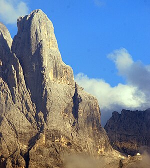
Cima della Madonna from the northwest (San Martino). View of the Schleierkante, the Velohütte at the bottom right |
||
| height | 2752 m slm | |
| location | Trentino , Italy | |
| Mountains | Dolomites , subgroup Pala group | |
| Dominance | 0.21 km → Sass Maor | |
| Coordinates | 46 ° 13 '56 " N , 11 ° 50' 44" E | |
|
|
||
| First ascent | 1886 by Winkler and Zott | |
| Normal way | Climbing tour out of the gap between Sass Maor and Cima della Madonna | |
|
Cima della Madonna (roughly in the middle of the picture to the right of the apparently highest peak, the Sass Maor ) from the Pala di San Martino . To the right of the center of the picture the Cima di Ball and in front of it the Campanile Pradidali |
||
The Cima della Madonna ( 2752 m slm ) is a mountain in the Trentino Dolomites . The Cima della Madonna is an important climbing mountain, especially because of its northwest edge, the so-called Schleierkante .
Location and surroundings
The Cima della Madonna, together with the Sass Maor to the east, forms the southern end of the central part of the Pala group . The most important place near the mountain is San Martino di Castrozza in the northeast, Fiera di Primiero to the south .
Bases and paths
The base for the ascent of the Cima della Madonna is the nearby Rifugio Velo della Madonna . Even the normal ascent to the Cima della Madonna requires climbing ability at level IV (UIAA) . It leads from the saddle between Cima della Madonna and Sass Maor over the east side to the summit and is also used for the descent.
The Cima della Madonna became known and famous in mountaineering circles through the veil edge ( Italian spigolo del velo , V +), which was often described as one of the most beautiful climbs in the medium difficulty range in the Dolomites, if not the entire Limestone Alps.
Further routes in the north face reach difficulties up to 6b +, the west face is made accessible by ascents up to the VII degree. In the south-west and south-facing walls there are routes up to level 6b +. There are some shorter sport climbing routes on the western base of the mountain above the Velohütte .
history
The first ascent of the Cima della Madonna was made by Georg Winkler and Alois Zott on August 12, 1886, essentially along today's normal route. On July 19, 1920, Gunther Langes and Erwin Merlet managed the first ascent of the Schleierkante, which subsequently developed into one of the most popular climbing routes in the Pala and the entire Dolomites. Langes traced the name "veil edge" back to the similarity of the mountain with a statue of the Madonna; the north-west edge was supposed to represent its veil.
In the second half of the 20th century, numerous routes of higher difficulty were opened, such as Via Messner (VI-) by Reinhold and Günther Messner in 1968. The most important follow-up was Maurizio Zanolla , who started with Via dei Piazaroi (VII, 1978) and Pigrizia intestinale (6b +, 1988) was able to climb two new tours for the first time. The last new tour for the time being on the Cima della Madonna is the Via Mega Maria (VI +) , which was opened in 1995 .
literature
- Annette Köhler, Norbert Memmel: Climbing Guide Dolomites . Rother Selection series, Bergverlag Rother, Munich 1993, ISBN 3-7633-3015-1 .
- Gunther Langes: Dolomites climbing guide 1b, Sella, Marmolata and Pala groups . Bergverlag Rother, Munich 1974, ISBN 3-7633-2303-1 .
- Bepi Pellegrinon (Ed.): Gunther Langes - Schleierkante . Nuovi Sentieri Editore, Belluno 2000.
Web links
- Cima della Madonna on Summitpost.org
Individual evidence
- ↑ Alexander Putz: Schleierkante - north-west edge. ( Page no longer available , search in web archives ) Info: The link was automatically marked as defective. Please check the link according to the instructions and then remove this notice. bergstieg.com; Retrieved October 12, 2010
- ^ Gunther Langes: veil edge . In: Bepi Pellegrinon (ed.): Gunther Langes - Schleierkante . Nuovi Sentieri Editore, Belluno 2000.
- ↑ Samuele Scalet et al. a .: Pale di San Martino . Versante Sud, Milano 2002, p. 220-231 .


