Circleville, Ohio
| Circleville | ||
|---|---|---|
|
Location in Ohio
|
||
| Basic data | ||
| Foundation : | 1810 | |
| State : | United States | |
| State : | Ohio | |
| County : | Pickaway County | |
| Coordinates : | 39 ° 36 ′ N , 82 ° 56 ′ W | |
| Time zone : | Eastern ( UTC − 5 / −4 ) | |
| Residents : | 13,485 (as of: 2000) | |
| Population density : | 788.6 inhabitants per km 2 | |
| Area : | 17.4 km 2 (approx. 7 mi 2 ) of which 17.1 km 2 (approx. 7 mi 2 ) is land |
|
| Height : | 212 m | |
| Postal code : | 43113 | |
| Area code : | +1 740, 420 | |
| FIPS : | 39-15070 | |
| GNIS ID : | 1056803 | |
| Website : | ci.circleville.oh.us | |
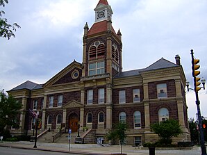
 Pickaway County Courthouse in Circleville |
||
Circleville is a city on the Scioto River in Pickaway County in the American state of Ohio , about 20 km south of Columbus . Circleville has a population of approximately 13,500 (as of the 2000 census ) and is the seat of the administrative district of Pickaway County .
Circleville is home to a number of Grade I listed buildings (from the time of Ohio's white colonization) and ground memorials (from the Hopewell culture ) that are on the National Register of Historic Places (NRHP).
history
When Circleville was founded in 1810, there were several traces of prehistoric settlement from the Hopewell culture, including a square and a circular rampart . The circular rampart was surrounded by two concentric earth walls, each about 6 m high. There was a deep trench between the walls. A square place was enclosed by the ramparts, which was surrounded by another rampart 3 m high. Eight breakthroughs in this innermost wall led to the square.
Even if the prehistoric complex was only partially preserved in 1810, it served as a floor plan for the city: it was laid out around a circular public square. In the middle of the square, a courthouse with an octagonal floor plan was built. Two streets formed concentric circles with the square as the center of the circle. Four streets led away from the square like spokes from the center of the city. The court house was destroyed by fire in 1841. In 1846 the city's circular layout was abandoned by the citizens and replaced by a conventional grid pattern . Today only a few buildings are left whose floor plan contains circular segments . The name of the city ( Circle ) is derived from the original form of the city map, which is quite unusual for the United States.
One of the city's founding fathers was George W. Hitler (1845–?), Whose ancestors immigrated to the United States in the mid-18th century. Nothing is known of any relationship to Adolf Hitler . The descendants of George W. Hitler formed an important local family. Three streets (Hitler No. 1 Road, Hitler No. 2 Road and Huber-Hitler Road) and a cemetery (Hitler-Ludwig Cemetery) were named after the family and are still called that today.
Personalities
- Caleb Atwater (1778–1867), lawyer and archaeologist, member of the Ohio House of Representatives . As one of the first to describe the settlement traces from the Hopewell and Adena cultures in the Ohio Valley .
- John Cradlebaugh (1819-1872), the first deputy for the Nevada Territory in the US Congress .
- Conchata Ferrell (born 1943), film actress. (Grew up in Circleville.)
- Ted Lewis (1890–1971), jazz musician, band leader and entertainer
- Lee Moore (1914–1997), country musician
- Jack Sensenbrenner (1902–1991), Mayor of Columbus (OH) from 1954 to 1960 and from 1964 to 1972.
- Sammy Stewart (1894-1960), jazz musician
- Kohl Sudduth (* 1974), film actor (grew up in Circleville.)
Web links
Individual evidence
- ^ OHIO - Pickaway County on the National Register of Historic Places.
- ^ Federal Writers' Project (Editor): The Ohio Guide . Oxford University Press, 1940, pp. 568-571.
-
^ Associated Press: The Circleville, Ohio, Hitlers . In: "Ynetnews" ( Jedi'ot Acharonot ) from June 23, 2005.
Google Earth now without "Hitler-Berg" in Der Spiegel from March 20, 2007.
