Colonie (New York)
| Colony | ||
|---|---|---|
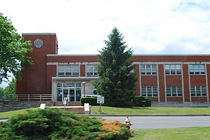
 town hall |
||
 seal |
||
| Location in New York | ||
|
|
||
| Basic data | ||
| Foundation : | 1895 | |
| State : | United States | |
| State : | new York | |
| County : | Albany County | |
| Coordinates : | 42 ° 43 ′ N , 73 ° 50 ′ W | |
| Time zone : | Eastern ( UTC − 5 / −4 ) | |
| Residents : | 81,591 (as of 2010) | |
| Population density : | 562.7 inhabitants per km 2 | |
| Area : | 150 km 2 (approx. 58 mi 2 ) of which 145 km 2 (approx. 56 mi 2 ) are land |
|
| Height : | 105 m | |
| Postcodes : | 12047, 12110, 12189, 12204, 12205, 12211, 12241, 12303, 12304, 12309 | |
| Area code : | +1 518 | |
| FIPS : | 36-17343 | |
| GNIS ID : | 0978853 | |
| Website : | www.colonie.org | |
| Mayor : | Paula A. Mahan ( D ) | |
 Philip Schuyler House |
||
Colonie is a town in Albany County in the US state of New York .
The place, which includes the Hamlets Latham with the Albany International Airport and Loudonville with the Siena College and the Albany Rural Cemetery , is located on the northern city limits of Albany between the Mohawk River (here part of the Erie Canal ) in the north and the Hudson River to the west on the Albany – Eagle Bridge railway line .
Personalities
- William T. Byrne (1876–1952), politician
- Nicholas T. Kane (1846–1887), politician
- Rollin B. Sanford (1874–1957), politician
- Philip Schuyler (1733–1804), general in the American War of Independence
credentials
- ↑ Town of Colonie in the Geographic Names Information System of the United States Geological Survey , accessed July 30, 2016
Web links
Commons : Colonie, New York - Collection of images, videos, and audio files
