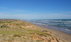
Coorong National Park
| Coorong National Park | ||
|---|---|---|
| Younghusband Peninsula | ||
|
|
||
| Location: | South Australia , Australia | |
| Specialty: | Coastal landscape with dunes and lagoon | |
| Next city: | Meningia | |
| Surface: | 467 km² | |
| Length: | 145 | |
| Founding: | 1967 | |
The Coorong National Park is a national park on the coast of the Australian state of South Australia , 156 km south-east of Adelaide . The western boundary of the park is at the mouth of the Murray River . Part of the park is the Younghusband Peninsula , a 145 km long, narrow peninsula that runs parallel to the coast .
The park was established in 1966 as a sanctuary for birds, animals and fish. Migratory birds use the region as a stop on their migrations. The 467 km² of the park are formed by dunes, lagoons and coastal vegetation. A special feature of the Coorong is the mixing of fresh water from the Murray River and the groundwater with salt water from the Southern Ocean in the area between the peninsula and the mainland, which enables a diverse flora and fauna.
Archaeological finds of artifacts and Aboriginal burial sites indicate that the region was used by humans for thousands of years. The term "Coorong" has its origin in the language of Ngarrindjeri and means something like "long neck" (dt. Long neck ).
Web links
- Official website (English)
- Australian Travel Guide: the Coorong (English)
- All about the Coorong (English)


