Cordobang
|
Cordobang
City of Bad Blankenburg
Coordinates: 50 ° 40 ′ 15 ″ N , 11 ° 12 ′ 25 ″ E
|
|
|---|---|
| Height : | 428 m |
| Residents : | 87 (Dec 31, 2015) |
| Incorporation : | March 8, 1994 |
| Postal code : | 07422 |
| Area code : | 036739 |
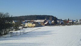
Cordobang is a district of the city of Bad Blankenburg in the Saalfeld-Rudolstadt district in Thuringia .
Geography and geology
The village is 410 m above sea level on a plateau between the lower Schwarza and Rinnetal valleys. The name is called Bergwiese and is derived from Old High German (Wang). These areas are also located in the slate mountains of the Thuringian Forest. The place can be reached via the local connection road which branches off the federal highway 88 in Quittelsdorf via Fröbitz. The neighboring villages of Cordobang are Fröbitz and Böhlplatten .
history
The hamlet was first mentioned in a document in 1071. Until 1918 the place belonged to the sovereignty of the Principality of Schwarzburg-Rudolstadt . A fortified church is first mentioned in 1074, the next time the church is mentioned in 1653. On July 1, 1950, the previously independent community of Fröbitz was incorporated.
economy
Cordobang is oriented towards agriculture and forestry. Tourism also plays a bigger role.
Web links
Individual evidence
- ^ Official website of Bad Blankenburg
- ^ Otto Dobencker : Regesta diplomatica necnon epistolaria historiae Thuringiae. Volume 1: (approx. 500-1152). Gustav Fischer, Jena 1896, pp. 186–187, no. 893 .
- ↑ Cordobang on the website of the city of Bad Blankenburg.Retrieved on July 18, 2011.
