Cruce Culta
| Cruce Culta | ||
|---|---|---|
| Basic data | ||
| Residents (state) | 1520 pop. (2012 census) | |
| height | 4098 m | |
| Post Code | 04-0201-0200-5001 | |
| Telephone code | (+591) | |
| Coordinates | 19 ° 4 ′ S , 66 ° 12 ′ W | |
|
|
||
| politics | ||
| Department | Oruro | |
| province | Eduardo Avaroa Province | |
| climate | ||
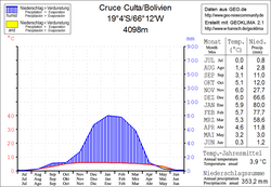
 Climate diagram Cruce Culta |
||
Cruce Culta (formerly: Ventilla ) is a town in the Oruro department in the highlands of the South American Andean state of Bolivia .
Location in the vicinity
Cruce Culta is the central place of the canton Culta in the municipality Challapata in the province Eduardo Avaroa . The village lies at an altitude of 4098 m on a plateau in the headwaters of various streams, which lead from here in all directions. The closest river course is the Río Jachcha , which flows over the Río Jalsuri to the Río Grande . A few kilometers west of Cruce Culta, the summit of Cerro Quesani rises to an altitude of more than 5000 meters.
geography
Cruce Culta is located on the eastern edge of the Bolivian Altiplano in front of the Cordillera Azanaques , which is part of the Cordillera Central mountain range . The region's climate is typical of the time of day , in which the mean daily temperature fluctuations are more pronounced than the seasonal fluctuations.
The average annual temperature of the region is 4 ° C (see climate diagram Cruce Culta) and fluctuates between 0 ° C in June and July and 6 ° C from November to January. The annual precipitation is only 350 mm, with a pronounced dry season from April to October with monthly precipitation below 15 mm, and significant precipitation only from December to March with 60 to 80 mm monthly precipitation.
Transport network
Cruce Culta is located at a distance of 208 kilometers by road southeast of Oruro , the capital of the department of the same name.
From Oruro, the paved national road Ruta 1 leads 116 kilometers south to Challapata , where the Ruta 30 branches off to Uyuni to the south . From Challapata, Ruta 1 then leads 80 kilometers via Ancacato and Thola Palca to Cruce Culta and on via Potosí to Tarija near the Argentine border.
population
The population of the village has more than quadrupled in the past two decades:
| year | Residents | source |
|---|---|---|
| 1992 | 320 | census |
| 2001 | 1 038 | census |
| 2012 | 1 520 | census |
Due to the historically grown population distribution, the region has a significant proportion of Quechua population, in the municipality of Challapata 59.2 percent of the population speak Quechua .
Individual evidence
- ↑ INE - Instituto Nacional de Estadística Bolivia 1992 ( Memento of the original from April 23, 2014 in the Internet Archive ) Info: The archive link was inserted automatically and has not yet been checked. Please check the original and archive link according to the instructions and then remove this notice.
- ↑ INE - Instituto Nacional de Estadística Bolivia 2001 ( Memento of the original dated February 23, 2014 in the Internet Archive ) Info: The archive link was inserted automatically and has not yet been checked. Please check the original and archive link according to the instructions and then remove this notice.
- ↑ INE - Instituto Nacional de Estadística Bolivia 2012 ( Memento of the original from July 22, 2011 in the Internet Archive ) Info: The archive link has been inserted automatically and has not yet been checked. Please check the original and archive link according to the instructions and then remove this notice.
- ↑ INE social data Potosí 2001 ( Memento of the original from December 15, 2011 in the Internet Archive ) Info: The archive link was inserted automatically and has not yet been checked. Please check the original and archive link according to the instructions and then remove this notice. (PDF; 5.5 MB)
Web links
- Relief map of the Cochabamba region 1: 250,000 (PDF; 10.6 MB)
- Relief map of the Rio Mulato region 1: 250,000 (PDF; 11.12 MB)
- Municipio Challapata - detailed map and population data (PDF; 811 kB) ( Spanish )
- Municipio Challapata - General Maps No. 40201
- Departamento Oruro - Social data of the municipalities (PDF; 5.86 MB) ( Spanish )
