Cufercal Hut
| Cufercalhütte SAC hut |
||
|---|---|---|
|
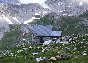
Cufercalhütte from the east |
||
| Mountain range | Splügen limestone mountains | |
| Regions | Rheinwald | |
| Geographical location: | 747 150 / 162030 | |
| Altitude | 2385 m above sea level M. | |
|
|
||
| owner | SAC Rätia | |
| Built | 1937 | |
| Construction type | Hut; Quarry stone masonry | |
| Usual opening times | June to mid-October (on the weekends) | |
| accommodation | 0 beds, 30 camps | |
| Winter room | 30 bearings | |
| Web link | Cufercal Hut | |
| Hut directory | SAC | |
The Cufercalhütte is a mountain hut of the Rätia section of the Swiss Alpine Club (SAC) in the canton of Graubünden .
The hut, built in 1937 from quarry stone masonry , is located in the area of the Andeer municipality north of Sufers at 2385 m above sea level. M. southwest of Piz Vizan at the southern foot of Piz Calandari . The hut offers 30 beds and is manned on weekends from June to mid-October. A shelter offers space for seven people in winter.
In 1954, with the reintroduction of the ibex, the foundation stone for today's ibex colony was laid in this region.
Approaches
- Directly from the village of Sufers via Lai da Vons or Glattenberg
- From Schams (e.g. Andeer) via Pastgaglias, Caritsch
Transitions
- Farcletta digl Lai Pintg - Alp Anarosa - Wergenstein
- Farcletta digl Lai Pintg - Alp Anarosa - Carnusapass (Lai da Scotga) - Glaspass
- Farcletta digl Lai Pintg - Alp Anarosa - Alp Tumpriv - Piz Beverin
- Farcletta digl Lai Pintg - Farcletta digl Lai Grand - Alperschälli - Turrahus ( Thalkirch , Safien )
literature
- Ruedi Meier, Jürg von Känel : Directory of climbing areas for children , SAC 1997, ISBN 3-85902-167-2
- Manfred Hunziker: Club Guide Bündner Alpen 2, Vom Lukmanier zum Domleschg , SAC 1996 (5th edition), ISBN 3-85902-154-0

