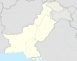
Dalbandin
| Dalbandin | ||
| State : |
|
|
| Province : | Balochistan | |
| Coordinates : |
28 ° 53 ' N , 64 ° 25' E
|
|
| Height : |
843 m
|
|
| Residents : | 16,319 (2017) | |
| Time zone : | PST ( UTC + 5 ) | |
| Telephone code : | (+92) 0825
|
|
|
|
||
Dalbandin (Baluchi: دالبندین) is a small town in Balochistan Province , Pakistan . The city is the administrative seat of the Chagai District and Tehsils Dalbandin. The city itself has 16,319 inhabitants, the surrounding rural Tehsil 110,503.
Geographical location
Dalbandin is located in the west of the Balochistan Province, about 80 km south of the border with Afghanistan ( Helmand Province ) and about 300 km east of the border with Iran (as the crow flies), in an elongated valley that runs from east-northeast to west-southwest and is up to 7 km wide between the Chagai Hills in the north, which rise to a height of about 2400 m, and the Ras Koh Hills in the south.
Transport links
The N-40 national road runs through this valley and through Dalbandin from Quetta (290 km to Dalbandin) west to the border with Iran at Taftan or Mīrjāveh , with the original city center south and extensive new residential areas (Killi Rasool Bakhsh Sumalani, Feisal Colony, Zahoor Colony) lie north of the road. In order to avoid the inner city, a bypass road now leads in the north through the outskirts of the new settlements. The only other road or track leading out of Dalbandin goes north-east to Chagai, about 60 km away, and from there another 25 km to the vicinity of the Afghan border. On unpaved slopes, robust off-road vehicles can also be used to drive southeast towards Kharan or west and northwest to scattered settlements in the Chagai Hills.
The approximately 750-kilometer-long Quetta – Zahedan railway ( Trans-Baluchistan Railway ) runs parallel to the N-40 national road from Quetta west to the border crossing at Taftan and on to Iran, with a train station in Dalbandin. The line is the only rail link between Pakistan and Iran and part of the only rail link between Europe and the Indian subcontinent . Twice today operates a passenger train in the month, and since June 2015, moves back a container - pair of trains per week.
The Dalbandin Regional Airport ( IATA code DBA) is located immediately southwest of the city. It has a 1,525 m long runway and is served by Pakistan International Airlines with flights to Turbat and Karachi . In the fight against the Taliban in Afghanistan, it was and is also used by US armed forces.
climate
Dalbandin has a pronounced desert climate, referred to as “BWh” in the Köppen and Geiger climate classification , with very hot summers and cold winters. The annual rainfall is only 81 mm and average maximum temperatures exceed 42 degrees Celsius in June and July ; The record was 51.4 degrees Celsius. Rain, and occasionally a little snow, practically only falls in the winter months.
| Dalbandin | ||||||||||||||||||||||||||||||||||||||||||||||||
|---|---|---|---|---|---|---|---|---|---|---|---|---|---|---|---|---|---|---|---|---|---|---|---|---|---|---|---|---|---|---|---|---|---|---|---|---|---|---|---|---|---|---|---|---|---|---|---|---|
| Climate diagram | ||||||||||||||||||||||||||||||||||||||||||||||||
| ||||||||||||||||||||||||||||||||||||||||||||||||
|
Monthly average temperatures and rainfall for Dalbandin
|
||||||||||||||||||||||||||||||||||||||||||||||||||||||||||||||||||||||||||||||||||||||||||
Footnotes
- ↑ POPULATION AND HOUSEHOLD DETAIL FROM BLOCK TO DISTRICT LEVEL: BALOCHISTAN (CHAGAI DISTRICT) (PDF; 37 kB)
- ^ Zahedan - Quetta line . In: IBSE telegram 296, July 2015, p. 7.
- ↑ Zahidan Passenger Train timing. In Pakistan Railway Time Table , accessed August 20, 2017
- ^ Great Circle Mapper: DBA Airport
- ↑ Dalbandin Climate & Temperature In: ClimaTemps.com
- ↑ National Oceanic and Atmospheric Administration: Dalbandin Climate Normals 1961–1990
