Dewladowe
| Dewladowe | ||
| Девладове | ||

|
|
|
| Basic data | ||
|---|---|---|
| Oblast : | Dnepropetrovsk Oblast | |
| Rajon : | Sofiyivka Raion | |
| Height : | 131 m | |
| Area : | 1.308 km² | |
| Residents : | 907 (2013) | |
| Population density : | 693 inhabitants per km² | |
| Postcodes : | 53132 | |
| Area code : | +380 5650 | |
| Geographic location : | 48 ° 6 ' N , 33 ° 45' E | |
| KOATUU : | 1225282501 | |
| Administrative structure : | 5 villages , 1 settlement | |
| Address: | вул. Привокзальна 10 53132 с. Девладове |
|
| Website : | official website | |
| Statistical information | ||
|
|
||

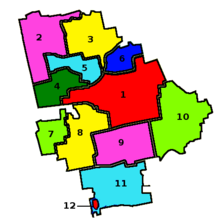
Dewladowe ( Ukrainian Девладове ; Russian Девладово Dewladowo ) is a settlement in the Ukrainian Oblast Dnipropetrovsk with about 900 inhabitants (2012) and the administrative seat of the district council of the same name.
history
The village arose after the construction of a granary and a railway station of the Katharinenbahn built for the grain trade in 1884. From 1965 to 1983 the company VostGOK, located 56 km northwest of Schowti Wody , extracted uranium from Dewladowe , which resulted in significant chemical and radioactive contamination of Led to soil and groundwater.
geography
The settlement is located on the territorial road T-04-19 in the northwest of Rajon Sofijiwka 12 km north west of the Rajonzentrum Sofijiwka , 100 km south-east of Oblastzentrum Dnipro and 30 km northeast of Kryvyi Rih . The Dnipro – Krywyj Rih railway line runs through Dewladowe.
Neighboring communities
| Ordo-Vasylivka | Marje-Dmytrivka | Marje-Dmytrivka |
| Shevchenkivske (Krywyj Rih) / Rajon Krywyj Rih |

|
|
| Shevchenkivske (Kryvyi Rih) | Nadeschdiwka (Krywyj Rih) / Rajon Krywyj Rih | Sofiivka |
Landratsgemeinde
The district council of Dewladowe was founded in 1925 and has an area of 72.22439 km² and a population of 2018. The population density is 28 inhabitants per km². The following villages also belong to the district council:
- Vodjane (Ukrainian: Водяне ; Russian: Водяное Vodjanoje ) ⊙ ; 230 hectares, 644 inhabitants
- Wessele Pole (Ukrainian: Веселе Поле ; Russian: Весёлое Поле Wesjoloje Pole ) ⊙ ; 131.3 hectares, 240 inhabitants
- Honcharowe (Ukrainian: Гончарове ; Russian: Гончарово Gontscharowo ) ⊙ ; 52.3 hectares, 102 inhabitants
- Hruschky (Ukrainian: Грушки ; Russian: Грушки / Gruschki ) ⊙ ; 29.3 hectares, 19 inhabitants
- Selenyj Hai (Ukrainian: Зелений Гай ; Russian: Зелёный Гай Seljony Gai ) ⊙ ; 62.2 hectares, 106 inhabitants

