
Dhulikhel
| Dhulikhel Nagarpalika धुलिखेल नगरपालिका Dhulikhel |
|||
|---|---|---|---|
|
|||
| Coordinates | 27 ° 37 '10 " N , 85 ° 33' 8" E | ||
| Basic data | |||
| Country | Nepal | ||
| Bagmati | |||
| District | Kabhrepalanchok | ||
| ISO 3166-2 | NP-P3 | ||
| height | 1556 m | ||
| surface | 12.1 km² | ||
| Residents | 14,283 (2011) | ||
| density | 1,182.4 Ew. / km² | ||
| Website | www.mundhulikhel.gov.np | ||
| 9 wards | |||
 Temple Square with Narayanthan Temple
|
|||

Dhulikhel is a city ( municipality ) and the administrative seat of the Kabhrepalanchok district in Nepal , approx. 25 km east of Kathmandu .
The city is located on Araniko Rajmarg , an important highway from Kathmandu to the Sino-Nepal Friendship Bridge on the border with Tibet . At the same time, it is the starting point of the BP Koirala Rajmarg , an almost completed road connection in the eastern Terai .
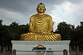
The well-preserved old town in the Newar style with some pagoda temples makes Dhulikhel an important tourist center in Nepal. In the southeastern part of the village, a stairway leads up to a golden Buddha statue and even further up to the Kali Temple or to a viewing platform with a view of the central Himalayan massif. The city has a renowned hospital and is home to Kathmandu University . The urban area covers 12.08 km².
Residents
At the 2011 census, Dhulikhel had 14,283 inhabitants (7,122 male) in 3,279 households.
gallery

Harisiddhi Temple at Temple Square

Ganesh temple

Shree Bhagawati Temple
Shanti Ban stupa

Kalidevi temple


Web links
Individual evidence
- ↑ Municipal Association of Nepal (MuAN) ( Memento of the original from January 7, 2014 in the Internet Archive ) Info: The archive link was inserted automatically and has not yet been checked. Please check the original and archive link according to the instructions and then remove this notice.
- ↑ National Population and Housing Census 2011 (PDF) Central Bureau of Statistics. Archived from the original on July 31, 2013.