Concepción District (Concepción)
| Concepción District | |
|---|---|
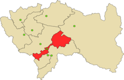
 The district of Concepción is centrally located in the province of Concepción (marked in red) |
|
| Basic data | |
| Country | Peru |
| region | Junín |
| province | Concepción |
| Seat | Concepción |
| surface | 18.2 km² |
| Residents | 16,169 (2017) |
| density | 888 inhabitants per km² |
| founding | January 2, 1857 |
| ISO 3166-2 | PE-JUN |
| Website | municoncepcion.gob.pe (Spanish) |
| politics | |
| Alcalde Provincial | Benjamin Próspero De la Cruz Palomino (2019-2022) |
| Political party | Movimiento Político Regional Perú Libre |
| Administration building in Concepción | |
Coordinates: 11 ° 55 ′ 9 ″ S , 75 ° 18 ′ 45 ″ W.
The district of Concepción is located in the province of Concepción in the Junín region in central Peru . The district was founded on January 2, 1857. It has an area of 18.2 km². The 2017 census counted 16,169 inhabitants. In 1993 the population was 12,720, in 2007 14,131. Seat of the district administration is 3283 m provincial highly preferred Concepcion with 14,049 inhabitants (2017).
Geographical location
The district of Concepción is located in the Andean highlands on the left bank of the Río Mantaro, which flows to the southeast, in the center of the province of Concepción.
The district of Concepción borders in the southwest with the district Mito , in the northwest with the district Matahuasi , in the north with the district Nueve de Julio , in the northeast with the districts Santa Rosa de Ocopa and Quichuay and in the east with the district San Jerónimo de Tunán (the the latter two districts are in the province of Huancayo ).
Individual evidence
- ↑ a b PERU: Junín region - provinces and districts . www.citypopulation.de. Retrieved June 13, 2020.
