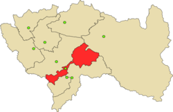
Orcotuna district
| Orcotuna district | |
|---|---|
 The Orcotuna District is located in the southwest of the Concepción Province |
|
| Basic data | |
| Country | Peru |
| region | Junín |
| province | Concepción |
| Seat | Orcotuna |
| surface | 45.2 km² |
| Residents | 4738 (2017) |
| density | 105 inhabitants per km² |
| founding | January 2, 1857 |
| ISO 3166-2 | PE-JUN |
| Website | muniorcotuna.gob.pe (Spanish) |
| politics | |
| Alcalde District | Mario Antonio Grande Bueno (2019-2022) |
| Iglesia Matriz de San Francisco de Orcotuna | |
Coordinates: 11 ° 58 ′ 1 ″ S , 75 ° 18 ′ 27 ″ W.
The Orcotuna district is located in the Concepción Province in the Junín region in central Peru . The district was founded on January 2, 1857. It has an area of 45.2 km². The 2017 census counted 4738 inhabitants. In 1993 the population was 4021, in 2007 4056. The district administration is located in the 3250 m high town of Orcotuna with 3525 inhabitants (as of 2017). Orcotuna is 5.5 km south of the provincial capital Concepción .
Geographical location
The Orcotuna district is located in the Andean highlands on the right bank of the south-east flowing Río Mantaro in the south-west of the province of Concepción.
The Orcotuna district is bordered on the southwest by the district Manzanares , in the northwest on the district Aco , on the north by the district Mito , in the northeast on the district of San Jerónimo de Tunan ( province of Huancayo ) in the easternmost part of the district of San Pedro de Sano ( Huancayo Province) and in the southeast to the Sicaya District (also in the Huancayo Province).
Individual evidence
- ↑ a b PERU: Junín region - provinces and districts . www.citypopulation.de. Retrieved May 9, 2020.
