Nasca district
| Nasca district | |
|---|---|
 The Nasca District is centrally located in the Nasca Province |
|
| Basic data | |
| Country | Peru |
| region | Ica |
| province | Nasca |
| Seat | Nasca |
| surface | 1,252.3 km² |
| Residents | 27,632 (2017) |
| density | 22 inhabitants per km² |
| founding | November 28, 1548 |
| ISO 3166-2 | PE-ICA |
| Website | www.muninasca.gob.pe (Spanish) |
| politics | |
| Alcalde Provincial | Julio Óscar Elías Lucana (2019-2022) |
| Political party | Movimiento Regional Obras por la Modernidad |
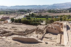
| Los Paredones, south of the city of Nasca | |
Coordinates: 14 ° 50 ′ S , 74 ° 56 ′ W
The Nasca District is located in the Nasca Province in the Ica region in southwestern Peru . The district was founded on November 28, 1548. It has an area of 1252.25 km² (according to other sources 1144 km²). At the 2017 census, there were 27,632 residents in the district. In 1993 the population was 23,463, in 2007 it was 26,062. The seat of the district administration is the provincial capital Nasca, 588 m high between the two headwaters of the Río Nazca , with 22,859 inhabitants (as of 2017).
Geographical location
The Nasca District extends over the central part of the Nasca Province as well as a smaller area in the northeast of the province. The southwestern district boundary runs close to the 15th southern parallel. The area consists almost entirely of desert.
The Nasca district is bordered to the west by the district Changuillo , on the north by the district El Ingenio , on the east by the district Leoncio Prado ( province Lucanas ), in the southeast of the district Vista Alegre and in the southwest of the district Marcona .
Web links
- Municipalidad Provincial de Nasca
- Peru: Region Ica (provinces and districts) at www.citypopulation.de

