San Agustín de Cajas district
| San Agustín de Cajas district | |
|---|---|
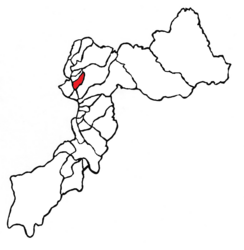
 Location of the district in Huancayo Province |
|
| Basic data | |
| Country | Peru |
| region | Junín |
| province | Huancayo |
| Seat | San Agustin de Cajas |
| surface | 23.1 km² |
| Residents | 15,281 (2017) |
| density | 662 inhabitants per km² |
| founding | March 20, 1940 |
| ISO 3166-2 | PE-JUN |
| Website | munisanagustin.gob.pe (Spanish) |
| politics | |
| Alcalde District | Victor Jorge Chipana Carrasco (2019-2022) |
Coordinates: 11 ° 59 ′ 22 ″ S , 75 ° 14 ′ 39 ″ W.
The district of San Agustín de Cajas is located in the Huancayo province of the Junín region in central western Peru . The district was established on March 20, 1940. It has an area of 23.09 km². At the 2017 census, 15,281 people lived in the district. In 1993 the population was 7,709, in 2007 10,267. The administrative center is the eponymous town of San Agustín de Cajas, 3250 m high, with 14,310 inhabitants (as of 2017).
Geographical location
The district of San Agustín de Cajas is located in the north of the metropolitan area of the provincial and regional capital Huancayo on the western edge of the Peruvian Central Cordillera . San Agustín de Cajas is located on the eastern bank of the south-flowing Río Mantaro, 9.5 km north-northwest of downtown Huancayo. The district has a lengthwise extension in SW-NE direction of 9 km and a width of almost 4.5 km. In the north, the district of San Agustín de Cajas borders on the district of Hualhuas , in the northeast and south on the district of El Tambo and in the west, on the opposite bank of the Río Mantaro, on the district of Sicaya .
Individual evidence
- ^ A b Peru: Junín Region - Provinces & Districts . www.citypopulation.de. Retrieved March 5, 2020.
