Huancán District
| Huancán District | |
|---|---|
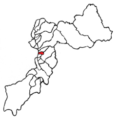
 Location of the district in Huancayo Province |
|
| Basic data | |
| Country | Peru |
| region | Junín |
| province | Huancayo |
| Seat | Huancan |
| surface | 12.3 km² |
| Residents | 24,830 (2017) |
| density | 2019 inhabitants per km² |
| founding | October 31, 1955 |
| ISO 3166-2 | PE-JUN |
| Website | munihuancan.gob.pe (Spanish) |
| politics | |
| Alcalde District | Edgar Vilcahuamán Ponce (2019-2022) |
| Political party | Movimiento Político Regional Perú Libre |
| Templo de Huarivilca | |
Coordinates: 12 ° 6 ′ 24 ″ S , 75 ° 13 ′ 0 ″ W.
The Huancán District is located in the Huancayo Province of the Junín Region in central western Peru . The district was established on October 31, 1955. It has an area of 12.3 km². At the 2017 census, there were 24,830 residents in the district. In 1993 the population was 7,677, in 2007 15,024. The administrative seat is the eponymous town of Huancán at an altitude of 3210 m , which is practically congruent with the district.
Geographical location
The district of Huancán is located in the Andean highlands in the south of the metropolitan area of the provincial and regional capital Huancayo . Huancán is 4.4 km south-southwest of downtown Huancayo. The district is located on the eastern bank of the south-flowing Río Mantaro and extends in the east to the foothills of the Peruvian Central Cordillera . The Huancán district is bordered to the north by the district of Chilca , the east by the district Sapallanga , the south by the district Huayucachi and the west by the district Tres de Diciembre ( province Chupaca ).
Individual evidence
- ^ A b Peru: Junín Region - Provinces & Districts . www.citypopulation.de. Retrieved March 4, 2020.
