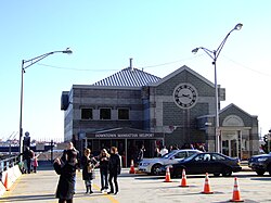
Downtown Manhattan Heliport
| Downtown Manhattan Heliport | |
|---|---|

|
|
| Characteristics | |
| ICAO code | KJRB |
| IATA code | JRB |
| Coordinates | |
| Height above MSL | 2 m (7 ft ) |
| Transport links | |
| Distance from the city center | 0.5 km south of Wall Street |
| Street | East River Drive |
| train | New York City Subway |
| Basic data | |
| opening | December 8, 1960 |
| operator | Saker Aviation Services Inc. |
| surface | 0.78 ha |
| Flight movements |
57,984 (2014/15) |
| Start-and runway | |
| H1 | 19 m × 19 m concrete |

The Downtown Manhattan Heliport (also: Wall Street Heliport ) is a helipad in the Financial District of Manhattan in New York City , on Pier 6 in the East River .
location
The heliport is not far from Brooklyn Bridge and Wall Street with the New York Stock Exchange . Owned by the Port Authority of New York and New Jersey since opening on December 8, 1960 , it was transferred to the New York City Economic Development Corporation (NYCEDC) in 2007 . NYCEDC commits the company Saker Aviation Services Inc. (formerly: FirstFlight ) in the course of a tender for the management and modernization of the heliport. Saker pledged to invest $ 2 million in the heliport.
use
Around 160 helicopters fly to the heliport every day. Most of the flights are passenger transportation to nearby airports such as Teterboro Airport , the Newark Airport or John F. Kennedy International Airport and tourist sightseeing flights .
The heliport is equipped with an arrival and departure terminal, but does not have a facility for refueling the helicopters.
Web links
- Downtown Manhattan Heliport site
- Airport data on World Aero Data ( 2006 )
Individual evidence
- ↑ AirportIQ 5010: Downtown Manhattan / Wall Street. GCR1.com, accessed October 2, 2017 .
- ^ Economic Development Corporation Is Seeking New Heliport Manager , nytimes.com, July 28, 2007
- ↑ airnav. From FAA Information Effective 29 July 2010
- ↑ http://www.newyorkhelicopter.com/helicopter-tours/ New York Helicopter Tours