
Dreisesselberg (Bavarian Forest)
| Dreisesselberg | ||
|---|---|---|
 View of the summit of the Dreisesselberg |
||
| height | 1333 m above sea level NN | |
| location |
Bavaria , Lower Bavaria , Freyung-Grafenau district |
|
| Mountains | Bavarian forest | |
| Dominance | 1.1 km → Hochkamm | |
| Coordinates | 48 ° 47 '5 " N , 13 ° 48' 9" E | |
|
||
| rock | coarse-grained granite | |

The Dreisesselberg ( Czech Třístoličník ) is a 1333 m above sea level. NN high mountain in the Bavarian Forest in Bavaria ( Germany ).
Geographical location
The Dreisesselberg is located in the Freyung-Grafenau district in the eastern part of Lower Bavaria . It rises southeast of the municipality of Haidmühle and northeast of the municipality of Neureichenau . At its northeastern foot starts at Světlá the Schwarzenberg Navigational Canal .
The Czech border runs about 370 meters southeast of the summit Dreisesselberg mountain over, the near the mountain Plöckenstein preferred triangle Germany- Austria - Czech Republic is located 3 km southeast of the Dreisesselberg mountain (distances each straight line ).
description
At the highest point of the Dreisesselberg, called Hochstein , there is a striking granite rock with a summit cross . In the once heavily forested area, large areas of the spruce died as a result of bark beetle infestation, which are still further on the area as dead wood and dominate the picture. However, the emergence of natural regeneration is already displacing this image of dead wood.
About 450 meters (as the crow flies) south of the Dreisesselberg summit is the Dreisesselfels, three bizarre granite rocks made of pillow-like boulders from the so-called wool sack weathering . Directly north of this rock group is the Dreisesselhaus ( 1312 m above sea level ) with the Dreisessel mountain inn . The German-Czech border runs a few meters to the east.
The public Dreisesselstraße leads up to the Dreisesselhaus, which is why the Dreisesselberg is often heavily frequented. There are also marked hiking trails from all directions, for example from the Kreuzbachklause, from Haidmühle-Frauenberg or the Czech Nové Údolí up the mountain.

On the western foothills of the Dreisesselberg, the Habergrasberg ( 1235 m above sea level ), there is the Dreisessel drag lift , a ski lift with a valley station in Haidmühle-Frauenberg. On the Bavarian side of the Dreisesselberg there is a nature reserve with a size of approx. 270 hectares. The parts of the eastern slope in Czech territory belong to the Šumava National Park (Bohemian Forest).
From the Dreisesselberg the Hochkamm ridge leads over the Bavarian Plöckenstein ( 1365 m above sea level ) and over the border triangle Germany-Austria-Czech Republic ( 1321 m ) to the main summit of the Plöckenstein ( 1378.3 m ) on the Austrian-Czech border . It runs along the German-Czech border and then further along the Austrian-Czech border. A little below it is the Plöckensteiner See , the southernmost glacial lake in the Bohemian Forest , in Czech territory .
Summit cliffs on the Dreisesselberg
The summit cliffs with the granites on the Dreisessel are designated by the Bavarian State Office for the Environment (LfU) as a geoscientifically valuable geotope (geotope number: 272R024). It was also awarded the official seal of approval for Bavaria's most beautiful geotopes by the LfU .
history
According to a legend that Adalbert Stifter also tells in his high forest , the kings of Bavaria, Bohemia and Austria are said to have gathered on the summit of the Dreisesselberg to negotiate the limits of their domains. In reality, the name “Dreisessel” did not come into use until the 17th century, initially for the striking rock group on the summit, but soon for the whole mountain. The exact course of the border between the bishopric of Passau and the Archduchy of Austria was only established in 1765 and measured in 1767. In addition to the story Hochwald in his last novel, Witiko , and in his last story, Aus dem Baierischen Walde (both 1867), Adalbert Stifter set the Dreisesselberg a literary monument. According to his reports, the Dreisesselberg was already a popular destination for hikers. As early as 1888, the Dreisessel section of the Bavarian Forest Association had the first shelter built. Next to this, the current building was built in 1913, which was modernized in the 1960s.
Picture gallery
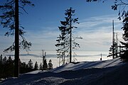
View to the southwest of the sea of fog in the valley

Summit cross of the Hochstein

Bishop Neumann Chapel
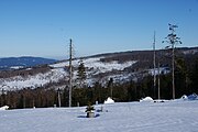
View to the southeast of the forest damaged by the bark beetle

Rock formations on the Dreisesselberg

View of the Czech side of the Dreisesselberg

_-_Hochstein_2.JPG)


Individual evidence
- ↑ Berggasthof Dreisessel
- ^ Bavarian State Office for the Environment, Geotop summit cliffs on the Dreisesselberg (accessed on March 22, 2020).
- ↑ Bavaria's most beautiful geotopes, Granite am Dreisessel (accessed December 10, 2017)
literature
- Adalbert Stifter: Witiko. Roman, 1867.
- Paul Praxl : The Dreiländerberg: borderland Bavaria-Bohemia-Austria. Morsak, Grafenau 1991, ISBN 978-3-87553-110-7 .
See also
- Dreisesselberg (Lattengebirge) - mountain near the southeastern corner of Bavaria