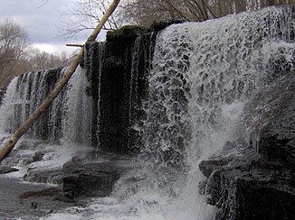
Duck River, Tennessee
| Duck River | ||
|
The catchment area of the Duck River and the Buffalo River |
||
| Data | ||
| Water code | US : 1269541 | |
| location | Tennessee (USA) | |
| River system | Mississippi River | |
| Drain over | Tennessee → Ohio → Mississippi → Gulf of Mexico | |
| source | in Coffee County 35 ° 40 ′ 7 ″ N , 86 ° 10 ′ 1 ″ W |
|
| muzzle | in the Tennessee River coordinates: 35 ° 56 '31 " N , 87 ° 56' 2" W 35 ° 56 '31 " N , 87 ° 56' 2" W. |
|
| Mouth height |
109 m
|
|
| length | 370 km | |
| Left tributaries | Buffalo River | |
|
"Blue Hole Falls": Duck River waterfall near Manchester (Tennessee) |
||
The Duck River with a total length of over 370 kilometers, the longest river which entirely in the State of Tennessee runs, and provides for irrigation of a considerable part of Middle Tennessee , the central part of the state.
The source of the Duck lies in a hilly landscape near the so-called "Barrens", an area in Middle Tennessee that was found deforested by the first European settlers . It flows through the city of Manchester , the county seat of Coffee County , and is then fed by one of its main tributaries, the Little Duck River , in a scenic location in "Old Stone Fort State Park" .
Other major cities on the Duck River include Shelbyville , Columbia, and Centerville . Above Shelbyville, the river is dammed by the Normandy Dam , which was built by the Tennessee Valley Authority (TVA) in the 1970s . Unlike previous TVA projects in Middle Tennessee, the dam was not built to generate electricity, but was only used for flood control and as a recreational area. It is named after the nearby hamlet of Normandy. The reservoir covers an area of more than 20 square kilometers of former arable land. Further downstream, levees and sluices serve to protect Shelbyville from flooding from the Duck. A dam built in the city center by the Tennessee Electric Power Company (TEPCO) still bears witness to the beginnings of electricity supply in the area before the TVA was established.
Further downstream, in Maury County , the Duck crosses the Yanahli Wildlife Preserve , which was set up on an area originally earmarked for another TVA reservoir. However, construction of the planned Columbia Dam was halted when it was discovered that an endangered freshwater mussel species was found in this section of the Duck , and studies showed that the cost of the project far exceeded its benefits. After years of litigation, the dam, which had already been largely completed, was demolished. The loss of the project was nearly $ 80 million in public money. Below this unfinished dam is another former TEPCO dam, similar to the one in Shelbyville. Efforts to resume power generation on this dam have so far not been successful, despite support from private funds (as of 2005). Columbia, with just under 40,000 inhabitants by far the largest city on the Duck River, is regularly affected by flooding during floods, to which the poorer urban areas are particularly exposed.
Between Columbia and Centerville, the Duck flows through the Western Highlands , where it is fed by the Piney River and other tributaries. Downtown Centerville is much higher than the banks of the Duck, which used to be cornfields. As Centerville became a suburb of Nashville , these fields were replaced by soccer fields. After Centerville the area around the Duck becomes more rural again. In southern Humphreys County , the Duck joins its largest tributary, the Buffalo River , before flowing into the Tennessee River just a few miles further . The estuary is part of the Tennessee National Wildlife Refuge .

