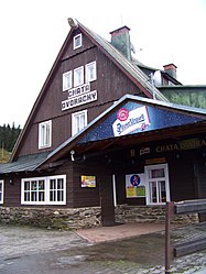
Dvoračky
| Chata Dvoračky | ||
|---|---|---|
|
The hut in 2009 |
||
| Mountain range | Giant Mountains | |
| Geographical location: | 50 ° 44 '51 " N , 15 ° 30' 44" E | |
| Altitude | 1140 m nm | |
|
|
||
| owner | Private | |
| Built | 1707/08 | |
| Development | Leśna droga 01021 | |
| Usual opening times | All year round | |
| accommodation | 7 rooms, 40 beds | |
| Web link | Homepage | |
Dvoračky (German Rochlitzer or Sahle Bacher Hofbaude ) is the Czech name of a mountain cottage on the southern side of the western Bohemian ridge in the Giant Mountains .
location
The hut stands in the middle of a clearing called Dvorské boudy ( Hofbauden ). It is located at an altitude of 1140 m at the northern end of the Vlčí hřeben ( Wolf's Ridge ) between the mountains Lysá hora ( Kahler Berg ) and Kotel ( Kesselkoppe ).
Hiking trails
Here, at an intersection, several paths meet with the “Bohemian Way”, which was already known in the 10th century.
▬ - Marked in red, this old trade route still leads today as a mountain path from Rokytnice nad Jizerou ( Rochlitz an der Iser ), which is about four kilometers southwest over the Labská louka ( Elbe meadow ) to Szklarska Poręba ( Schreiberhau ) in Silesia . A junction behind the Kotel leads, interrupted by a short stretch of road with green signs, over the Zlaté návrší ( Goldhöhe ) to Špindlerův Mlýn ( Spindleruv Mlyn ) (11 km).
▬ - Marked in green, the route initially leads to the Ručičky junction. Here you can either continue following the green sign and take the direct path (7.5 km) down to Harrachov ( Harrach village ) or you can take a blue path over the Čertova pláň ( Devil's Plan ), past the Studená ( Kaltenberg )mountainand the Rock formation Janova skála ( Johannesfelsen ) to Čertova hora ( Devil's Mountain ). From here you can also take the chairlift down to Harrachov.
▬ - Signposted in yellow, another route leads first to the Sedlo pod Dvoračkami pass ( Sedlo for short, translated as saddle under the farm hut ) and further along the western slope of the Wolf's Ridge with beautiful views of Rokytnice to theRezek hamlet (6 km).
▬ - Marked in blue, an alternative runs together with the yellow signposts to Sedlo, but here turns sharply to the right in orderto getto Huťský vodopád (German Hüttenbachfall )in the valley of Huťský potok (Hüttenbach). The waterfall cascades down to a total height of 20 meters. The path continues, past the clearing of the Huťská bouda , through a wild and romantic valley, which is named after the first glassworks in Rokytnice from 1562, before reaching the Rochlitz district of Rokytno (German Sahlenbach )after 4 km.
The red D on the left is a so-called " silent sign ", in Czech Němé značky , with which the poles of the winter marking to the farm house are marked.
history
The origin of the building goes back to the years 1707–1708, when, according to tradition, members of the Schier family built a simple alpine hut on this site. This was gradually expanded into a mountain farm because the surrounding meadows were ideal for raising cattle. In March 1893, however, the homestead fell victim to a fire. Count Harrach later bought the ruined fire and had an inn built. The hut quickly became known in the up-and-coming tourism and was also frequently visited in winter. In February 1902 it was even the venue for the seventh Bohemian Ski Championships. After the Czechoslovak land reform of 1919 and the partial expropriation of the large landowners, the building became state property in 1921 and was leased to the Czech Puhonní family, who later bought it. According to the guest book, the prominent visitors included President Edvard Beneš and his wife Hana, who both loved the Krkonoše Mountains and had a rest on the Dvoračky before the war and in 1945.
Web links
- Hiking suggestion - From Hofbaude to the Harrach stones
Individual evidence
- ↑ The German additions to the name serve to distinguish the hut of the same name between the mountains Světlý vrch , Zadní Planina and Liščí hora .
- ↑ Bernhard Pollmann, "Riesengebirge: With Jizera Mountains. 50 tours. ”, Bergverlag Rother, 2017 . Google Books . Retrieved October 10, 2017.
- ^ History of the Hofbaude . Retrieved October 10, 2017.

