
Vlčí hřeben
| Vlčí hřeben
Wolf crest
|
||
|---|---|---|
.jpg) The three peaks of Wolf crest of a meadow below the mountain cottage Dvoračky seen from |
||
| height | 1140 m nm | |
| location | Liberecký kraj , Czech Republic | |
| Mountains | Giant Mountains | |
| Coordinates | 50 ° 43 '56 " N , 15 ° 30' 37" E | |
|
||
| rock | Phyllite , mica schist | |

The Vlčí hřeben (German Wolfskamm ) is the southern ridge of the mountain Lysá hora (German Kahler Berg ) in the western part of the Giant Mountains . The elongated ridge reaches its greatest height in the Vlčí hřeben "S" summit at 1140 meters.
location
The string of many small peaks stretches in a southerly direction over a length of about 2.9 kilometers to a saddle at the hamlet of Rezek (880 m) and from there another 2.3 kilometers to the Kobyla (German Kabila ) elevation (896 m) , 50 ° 41'22.58 ″ N, 15 ° 30′0.19 ″ E ), which forms the end near Vítkovice (German Witkowitz ). Other nearby villages are Horní and Dolní Mísečky ( Obere and Untere Schüsselbauden ) below the eastern slope and Rokytnice nad Jizerou (German Rochlitz an der Iser ) to the west .
According to the classification for main and secondary peaks, the Wolfskamm has a total of three peaks, none of which have their own name.
- The one already mentioned, with the letter "S", is the northernmost and steepest. It is located about 2.3 km south of the Lysá Mountain and has the coordinates 50 ° 43'56 "N, 15 ° 30'37" E .
- The middle peak does not need any additional letters. A distance of about 610 meters separates it from the north summit, which is 16 meters higher. Its coordinates are 50 ° 43'38 "N, 15 ° 30'24" O . The terrain is flat and without any prominent cliffs.
- About half a kilometer further south is the last of the three peaks of the Wolfskamm, which reaches a height of over 1,100 meters. The south summit is marked with a "J". A geodetic point is attached to the 1119 meter high, also flat and monotonous-looking level . The latitude and longitude is 50 ° 43'23 "N, 15 ° 30'25" O indicated.
Hydrology
The slopes of the ridge are relatively densely forested, so the water in the ground can be kept better than is the case, for example, with Kozí hřbety (German goat back ). Accordingly, the amount of precipitation that flows from here into the neighboring valleys is lower. The eastern slope drains into the Kozelský potok (German Koschelbach ), which flows into the Jizerka . This "Kleine Iser" - the German name - is a left tributary of the Jizera (German Iser ), which also receives the water of the western slope in the Huťský potok (German Hüttenbach ). The Iser is a large tributary to the Elbe and thus all of the named waters belong to the Elbe → North Sea river system .
Flora, fauna and nature conservation
The mountain is in the III. Protection zone of the Giant Mountains National Park . In contrast to the I and II zones, it is allowed to leave the marked hiking trails. The entire ridge and the slopes are, with a few exceptions, such as B. a narrow strip between the northern and central peaks covered by dense spruce forest. The crossbill , the rough-owl and some woodpecker species live here . Beeches and other deciduous trees grow in low areas ; rare plants such as arnica , gentian and anemone thrive in vacant spaces .
Cross-country ski trails, hiking and cycling trails
The easiest way up to the summit ridge, motorized or by bike, first follows road No. 294 , built in 1902 , which comes from the Rochlitz district of Františkov ( Franzental ) to the pass near Rezek and from here goes back down to Vítkovice. Rezek, which used to be called Jerusalem and was founded by Protestant refugees after the Battle of White Mountain , consists of only a few deserted farms and a restaurant. The small settlement is a good starting point for the routes of hikers, cyclists and, in winter, when most of the hiking trails are groomed as trails , for cross- country skiing tours.
▬ - Marked in green, a footpath from Rochlitz runs parallel to the road that is part of the Cyklotrasa (German bike path ) KČT No. 22. In Rezek, KRNAP cycle route no. 8, also marked in green, crosses it. The northern part of this route, which is also called the “excursion path”, leads below Rezek's local mountain, the Preislerův kopec (German Gabelberg , 1035 meters) on the eastern slope of the Wolfskamm to pass Sedlo pod Dvoračkami (short Sedlo translated saddle under the Hofbaude ) below the North Summit, where the bike path near the waterfall Kozelský vodopád (German Koschelfall ) into the still green marked KRNAP-cycle route no. 1A passes. Further on this path you come to the famous Bergbaude Dvoračky ( Rochlitzer Hofbaude in German).
In a southerly direction, the cycle path and the pass road run side by side for a short distance before the road turns left almost 900 meters beyond the outskirts of Rezek, leading to Vítkovice 100 meters below with a bend. The bicycle route, on the other hand, maintains the height that it leaves only at the end of the ridge on Kobyla and leads down the valley to Jestřabí v Krkonoších .
▬ - Yellow signs branches at the bus stop Pod Vlčím hřebenem (translated Bottom Wolf crest ) an alternative route called Vlčí cesta from the green trail and leads on the western slopes of Wolf Ridge along also on the Sedlo to Dvoračky mountain hut above. This route is less difficult than the "eastern" option and offers beautiful views of Rokytnice.
Two other hiking trails lead from Rokytno (German Sahlenbach ), a suburb of Rochlitz, to the 1025 meter high pass under the Hofbaude.
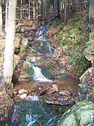
▬ - Marked in blue, a wild and romantic path runs through the valley of the Hüttenbach, which is named after the first glassworks in Rokytnice from 1562. We pass the Huťský vodopád (German Hüttenbachfall ) a waterfall that cascades down to a total height of 20 meters and the clearing of the Huťská bouda before reaching the Sedlo Pass.
▬ - The path with the name Jappencká cesta is marked in redhalfway between the paths with yellow and blue signs . Especially in winter, when it is used as a cross-country ski run, it is an alternative when the ascent to Sedlo from the lower path in the valley is closed.
In some hiking maps, another unofficial path is shown just below the ridge, but is not described here for nature conservation reasons.
Pictures from the area

View of Horní Rokytnice 1)

View of the Lysá hora from below the north summit

The Huťská bouda and ...
... the Hüttenbach nearby

Ascent from the Hüttenbach valley to Sedlo pod Dvoračkami

The Hüttenbachfall
.jpg)
.jpg)


.jpg)
1) The picture shows from left to right or from west to east the mountains Plešivec (German iceberg , 1210 m), Lysá hora (center of picture, 1344 m) and Kotel (German Kesselkoppe , 1435 m).
- The Vlčí hřeben above the extensive green area in the center of the picture hardly stands out against the somewhat hazy background.
Individual evidence
- ↑ a b Adventure weekend at Wolfkamm (Czech)
- ↑ History Rezeks
- ↑ Long descents
- ↑ Bernhard Pollmann, "Riesengebirge: With Jizera Mountains. 50 tours. ”, Bergverlag Rother, 2017 . Google Books . Retrieved June 18, 2017.