
Vlčí kámen
| Vlčí kámen
Vlčí hřeben / Wolfsstein
|
||
|---|---|---|
 Vlčí hřeben with the Vlčí kámen peak above Prameny |
||
| height | 883 m nm | |
| location | Okres Cheb , Karlovarský kraj , Czech Republic | |
| Mountains | Karlovy Vary Mountains (Karlovarská vrchovina) | |
| Coordinates | 50 ° 1 '51 " N , 12 ° 43' 42" E | |
|
||
| rock | Greenschist , serpentine group | |

The Vlčí kámen (German Wolfsstein ) is the summit of an elongated ridge in the Hornoslavkovská vrchovina (German Schlaggenwald mountainous region ) in the Sokolov district (German Falkenau an der Eger ) in the Czech Republic .
location
The highest point of about eight kilometers long Höhenzugs is an indication , that is a free-standing rock formation of serpentinite , reminiscent in shape to a lying wolf and is therefore namesake. The wooded hill belongs to the Slavkovský les (German Imperial Forest ) and runs in a northeast-southwest direction between the clearings around the villages of Prameny (German Bad Sangerberg ) below the northern slope as well as Sítiny (German Rauschenbach ) and Mnichov (German Einsiedl ) in the south.
In the west, about 4.5 kilometers from the summit and in the middle of the forest, is the small settlement Kladská (dt. Glatzen ), which was built around a hunting lodge founded in 1873 by Prince Otto Friedrich von Schönburg-Waldenburg . To the northeast, the height drops only slightly over a distance of a good two kilometers, then the ridge is interrupted by a saddle about 160 meters lower. The terrain then rises again to 800 meters in order to reach the contour line of the saddle at 700 meters above sea level south of Nová Ves u Sokolova (Eng. Neudorf bei Tepl ).
geology
The area is part of the so-called Marienbad metabasite complex, which is the largest accumulation of metamorphosed basic rocks within the Bohemian mass . The geological structure of the mountain consists of green slate and serpentinite rock, which emerges in outcrops in many places . The comb is known for its rich occurrence of opal and actinolite (ray stone) with crystals up to 15 centimeters in length and typically green in color. In addition, silver found and of Prameny to Kladská is one of the largest stretches tin - soaps in the country.
Hydrology
In the west, under the Králův kámen (German: Königstein ), lies the extensive peat bog area Kladské rašeliny (German: Glatzener Moor ), which is drained by several streams; two of them flow at the foot of the Vlčí hřeben in an easterly direction. On the north side this is the Pramenský potok ( Eng . Rodabach ). After leaving Prameny behind, the small river changes to the south side in a swampy floodplain at the aforementioned saddle. This is where the Mnichovský potok (German: Schöppelbach ) flows from the southwest , which previously absorbed the water from the southern slope. The thus strengthened Rodabach continues its course on the north side and after a sharp change of direction flows past Mnichov in many creek loops to the southeast of the Teplá . This in turn is a tributary of the Eger , which, like the other bodies of water mentioned, belongs to the Elbe → North Sea river system .
Flora, fauna and nature conservation
As part of the Imperial Forest, the area belongs to the Geopark Bavaria-Böhmen (Czech Geopark Bavorsko-Čechy ), there are a number of smaller nature reserves on the slopes:
Vlček.JPG) |
The nature reserve around the summit was founded in 1966. The reason for the protection is the natural pine forest that grows on a special soil substrate. The lack of calcium and the low nitrogen and phosphorus content are characteristic of serpentinites . On the other hand, due to the weathering of the serpentine , the soil has high proportions of magnesium , chromium and cobalt . These factors strongly influence the vegetation and produce a remarkable flora. The Scots pine ( Pinus sylvestris ) dominates, but rare plants such as bush carnation ( Dianthus sylvaticus ), snow heather ( Erica carnea ) and Turkish league ( Lilium martagon ) grow in between . To drier places one finds the book finial ( Polygala chamaebuxus ) and huperzia selago ( Huperzia selago ); in crevices the striped fern species Asplenium adulterinum and Asplenium cuneifolium . Many species of wild animals live on the wooded and rocky areas, including the endangered common toad ( Bufo bufo ) and birds such as the goat milker ( Caprimulgus europaeus ) and the eagle owl ( Bubo bubo ). |
|
Smraďoch.JPG) |
The Stinker is a unique forest peat moor south of the summit. Here, at a fault line in the amphibolite of the Marienbad ultrabasite complex, groundwater permeated with gas emerges. It is above all the content of hydrogen sulfide (H 2 S) that is formed with bacterial involvement in the reducing environment of the peat bog and is responsible for the penetrating smell of rotten eggs. For many cracks and small gaps, so-called mofettes flowing carbon dioxide (CO 2 ) from, the juvenile origin, d. that is, it comes from great depths, i.e. the earth's mantle . It is the last testimony to the earlier tectonic processes in this area. The colorless and odorless gas is heavier than air and is therefore responsible for the fact that almost only plants survive here and hardly any animals. In the past, peat was cut here for spa treatments in the nearby Marienbad ( Mariánské Lázně in Czech ). However, this use was ended in 1853 and the moor was left to its own devices again. After that, many protected plants have settled here, such as B. Common cranberry ( Vaccinium oxycoccos ) and the two carnivorous plants common butterwort ( Pinguicula vulgaris ) and round-leaved sundew ( Drosera rotundifolia ). ( GPS data ) |
|
Planý vrch.jpg) |
The Einsiedler Heide nature reserve has existed since 1996. The natural beauty of the area around this secondary peak is aptly described in the name, because "planý" means "wild". Until the first quarter of the 20th century, serpentinite was mined here. The remains of the old quarries have long since been recaptured by a plant society that has specialized in this subsoil. Most of the reserve is covered by old serpentinite pine stands. Common juniper ( Juniperus communis ) grows in between and, in addition to various striped ferns ( Asplenium ), including the brown-stemmed striped fern ( Asplenium trichomanes ), there are snow heather, mountain sedge ( Carex montana ), dwarf box ( Polygala chamaebuxus ) and a subspecies of the field scabious ( Knautia arvensis subsp. Serpentinicola ). ( GPS data ) |
|
Mokřady pod Vlčkem
.JPG) |
The wet meadow under the Vlček was announced as a nature reserve in December 1995. It is located near the summit, south of Prameny, and is one of the largest non-forested wetlands in the central part of the Kaiserwald. It is characterized by meadows, bog areas, small ponds and brooks and is surrounded by spruce forest on muddy ground. Here, too, like the stinker of mofettes, carbon dioxide is emitted . ( GPS data ) |

|
In 2008, the individual biotopes and some other sights in the northern part of the ridge were connected by the educational trail “Mnichovské hadce” (translated as hermit snake stones ). Detailed descriptions and useful information about the following locations are provided on display boards.
Pluhův bor |
The Pflug'sche Heide was set up as a biotope in 1970 to protect the typical plant communities that live on the serpentine soil. Among the rare and protected plants, the chickweed hornwort ( Cerastium alsinifolium ) deserves special mention. It is an endemic species and only occurs here and, very close, on the "Raušenbašská lada" (Eng. Rauschenbacher Heide ), between Sangerberg and Einsiedel. Also worth mentioning are a whole range of orchids, the blueberry willow ( Salix myrtilloides ), the carnivores common butterwort and round-leaved sundew as well as the arnica ( Arnica montana ), the symbol of the Kaiserwald nature reserve. The typical animal species here are red deer ( Cervus elaphus ), wild boar ( Sus scrofa ), roe deer ( Capreolus capreolus ) and some carnivorous species of marten (Mustelidae). It is also noteworthy that the westernmost occurrence of the European ground squirrel ( Spermophilus citellus ) is located here. Representatives of the bird world are black grouse ( Tetrao tetrix ), capercaillie ( Tetrao urogallus ) and black stork ( Ciconia nigra ). ( GPS data ) |
Dominova skalka
 |
The 757 meter high Domin rock was declared a natural monument in March 1989 and named after the Czech botanist Karel Domin , who researched the flora of the Imperial Forest around 1900. Many rare and protected plant species are represented in the area and represent the most developed serpentinite society of the Imperial Forest. In addition to heather ( Erica ) and box finial ( Polygala chamaebuxus ), diamond ferns ( botrychium ), eyebright ( Euphrasia ) and the critical also thrive here threatened Sudeten bedstraw ( Galium sudeticum ). Rare insect species also find their habitat between the grasses and stones, for example the field locust (Acrididae) or butterflies such as the swallowtail ( Papilio machaon ) and the great common butterfly ( Apatura iris ). ( GPS data ) |
Tři Křížky.JPG) |
The area around the Three Crosses was launched on December 22nd, 1962 by the Ministry of the Environment of what was then Czechoslovakia as a “national natural wonder”. It is separated by the Dlouhá stoka (German Flößgraben ), a 24 km long artificial canal that follows a natural fault line at the foot of the wolf's crest and, like the troll meadow below, no longer belongs to this geomorphological unit. According to one story, the crosses on the summit were erected in gratitude for the recovery of three brothers from a serious illness. At the beginning of spring the natural monument is bathed in a strong burgundy red by the flowering bushes of the bell heather. Unfortunately, access to the entire area is prohibited, and so is the promising view from the summit. ( GPS data ) |
Upolínová louka pod Křížky.jpg) |
The Troll field of flowers under the crosses enjoys as the neighboring biotope "Tři Křížky" status as a national natural landmark and is a good example of the marsh meadow communities of the Imperial Forest. It is named after the globe flower ( Trollius europaeus ). In addition to this endangered species, several types of orchids bloom here at 800 meters above sea level . B. the coral root ( Corallorhiza trifida ) and others, the majority of which are grouped with orchids . The swamp lice herb ( Pedicularis palustris ), the carnivorous butterwort ( Pinguicula vulgaris ) and the Siberian iris ( Iris sibirica ) also thrive here . The animal world is represented by reptiles and amphibians such as adder ( Vipera berus ), smooth snake ( Coronella austriaca ), slow worm ( Anguis fragilis ), various lizard species (Lacertidae) and mountain newt ( Ichthyosaura alpestris ). The meadow is populated by many different insects, including the raised bog yellow fling ( Colias palaeno ), an endangered species of butterfly. The place used to be an important mating ground for the black grouse, which is still found here in remnants today. Now it is more decisive for the living conditions of other birds, such as B. Quail ( Coturnix coturnix ) and Corn Corn ( Crex crex ), which also nest here. The black stork, which has a valuable hunting ground here, however, like the black woodpecker ( Dryocopus martius ) , nests in the nearby forest. ( GPS data ) |
history

The history of the landscape around the Wolfsstein is said to go back to the Bronze Age , when the tin deposits began to be exploited. However, there is no reliable evidence of mining until the 9th and 10th centuries. In the 14th century Prameny was founded as a mining settlement. The importance of the place still testifies to the so-called riding heap, to which the deaf rock was poured, which then remained.
The mineral water spring in the vicinity later enabled a bathing establishment , which was visited by Goethe in 1822 . The Elisabeth bath was opened in 1872. The most important wells for the spa operation were the Rudolph spring, the Giselle spring and the Vincenz spring.

In the first half of the 19th century, mining of the local serpentinite rock on Planý vrch began. It is a dense rock that appears in different color varieties depending on the deposit, with numerous greenish asbestos veins and reddish spots of bronzite . The color spectrum ranges from black, black-green to black-brown and dark green. In terms of color and texture, it is reminiscent of snakeskin and, with its polished surface, was very popular at that time as the so-called "hermit snake stone " ( Český hadec in Czech ).
Along the Mlýnský potok (dt. Mühlbach ) in Mnichov there were numerous grinding shops from 1834 to 1904 that processed the material into smaller everyday items and decorative objects, table tops and grave slabs. The decorative material was also used in the manufacture of building elements such as columns , cornices and balustrades .
Since 1911 there has been a restaurant under the summit, which burned to the ground shortly after the Second World War . The "Café Wolfsstein" offered its guests tourist attractions in every season. In winter there was a ski slope, a bobsleigh and toboggan run and a 15-meter ski jump. In summer, the spa guests could use the trout ponds of the in-house fish farm in Sangerberg as an outdoor pool.
After 1945, the Prameny military training area was laid out and an ammunition store was built near the former café. The troop camp was disbanded in the 1950s and relocated to Doupov (German: Duppau ) , the ammunition warehouse was used for military purposes by the garrison in Velká Hleďsebe (German: Groß Sichdichfür ) until 1996 .
photos
... of plants

Striped fern in a serpentine crevice

Siberian iris

Snow heather near the Tři Křížky

Carnation (Dianthus superbus)

Sundew and butterwort


.jpg)

… of animals

Goat milker
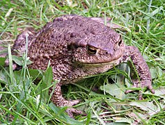
Common toad female

European ground squirrel

Black stork

Hochmoorgelbling


... and from the area

Path through the Glatzener Moor

Mnichovský potok

Small pond in the Mokřady area

fenced footpath by the Tři Křížky

Deadwood in Pluhův bor

.JPG)
.jpg)
.JPG)
.jpg)
Web links
Sights in Mariánské Lázně and the surrounding area Website of the official Mariánské Lázně tourism portal (multilingual)
Individual evidence
- ^ Walter Sperling's dictionary of geographical names
- ↑ a b c In the heart of the Imperial Forest Horní Slavkov - Prameny - Mnichov (Czech, German)
- ^ Website of the Friends of Slavkovský les (Czech)
- ↑ Characteristics of the Vlček area page of the "Česká geologická služba" (Czech Geological Service, Czech, English)
- ↑ a b History of Bad Sangerberg
- ↑ a b The Domin rock
- ↑ Maintenance plan for the Planý vrch nature reserve for the period 2013–2026 (Czech)
- ↑ The Smraďoch nature reserve
- ↑ The Planý vrch nature reserve
- ↑ Hans-Christian Friedrich: "Family Caryophyllaceae" . Paul Parey, Berlin / Hamburg 1979, ISBN 3-489-60020-7 , pp. 911 .
- ↑ The Pluhův bor nature reserve
- ↑ "The geognostic structure and geological development of the country", Dr. Friedrich Katzer, Verlag I. Taussig, Prague, 1892, pp. 254 ff. And p. 274 . Internet Archive . Retrieved May 3, 2017.
- ↑ The reserve Tri Křížky
- ↑ Upolínová louka pod Křížky
- ↑ The Vlček Nature Reserve