
Dlouhá stoka
| Dlouhá stoka Raft ditch |
|
|---|---|
 The canal at Kladské rašeliny (German: Glatzener Moor ) |
|
| location | Okres Cheb , Karlovarský kraj , Czech Republic |
| length | 24.2 km |
| Built | 1531 to 1536 |
| Expanded | 1601 to 1608 first major reconstruction, 1908 further corrections |
| Beginning | Kladský rybník (German Glatzener Teich ) ( 50 ° 1′40.7 ″ N, 12 ° 40′30.27 ″ E ) 810 m |
| The End | Krásno (German Schönfeld ) ( 50 ° 6'24.14 "N, 12 ° 46'58.94" E ) 720 m |
| The German name Flossgraben corresponds to the form as it was used in early New High German . A uniform spelling can then no longer be determined. The reason is the emergence of the characters ß and Ö , which led to name forms with o or ö , with ss , ß and the ligatures ſs or ſʒ . | |
The Dlouhá stoka (German float ditch ) is an artificially created watercourse , which was created in connection with the exploitation of the tin ore deposits in the Slavkovský les (German Imperial Forest ) in the Cheb district (German Eger ) in western Czech Republic .
course
The Long Graben , as the translation from the Czech reads , is one of the drains of the Kladský rybník (German Glatzener Teich ). It begins on the northern shore of the lake and follows natural break lines and contour lines from west to east. The German name derives from the fact that as a Floßgraben also for rafts of mining timber was used. Among other things, the shafts and routes in the mine were built with this wood to protect them from collapsing.
At the beginning the ditch flows parallel to the Pramenský potok (German Rodabach ), but in contrast to it turns north after four kilometers and makes a wide arc around the village of Prameny (German Sangerberg ). Again in the original direction of flow, it runs between the first elevations of the Vlčí hřeben (German Wolfskamm ) and the two national cultural monuments Tři Křížky (German Three Crosses ) and Upolínová louka pod Křížky (German Globeflower meadow under the crosses ), which lie above its left bank.
We continue in a north-easterly direction to the village of Nová Ves u Sokolova (German Neudorf bei Tepl ), where water is taken from a small treatment plant in order to supply the population with drinking water. Before the raft ditch in the village of Krásno ( Schönfeld in German ) flows into the Stoka brook, which has been developed as a canal , it makes half a circle around the Krasenský vrch mountain (Schönfelder Höhe, 777 m) with its stone, ziggurat-shaped observation tower.
The waterway was laid out with an average width of over two meters and an average gradient of 3.5 per thousand. The flow rate could be regulated with 14 weirs . Over a length of 24 kilometers without the secondary branches, which is only about half as much as the crow flies, 52 ore mills use the water of the Lange Graben . It absorbs the water of a large number of small brooks and ditches of minor importance, because in addition to ideal use of the natural gradient, it is optimized to be supplied with water as consistently as possible. The system of trenches is crossed by 35 bridges and, together with branches and ten large mine ponds, covers a total area of approximately seven hectares.
history
A large amount of water has always been necessary since mining began in the Kaiserwald. In addition to the drinking water supply, it was the most important source of energy for centuries, which was tapped with water wheels and served to drive various machines. Stamp mills and hammer mills were set in motion in this way. Most importantly, however, the water was used to power bilge pumps , which were used to lift seeping groundwater into the tunnels. If it was missing, it could be that the pits would flood in particularly dry summers . The same threatened in winter when the streams froze over. The water is also used to wash out and clean the ore during the various stages of ore extraction.
The medieval tin mines around Horní Slavkov (German Schlaggenwald ) and elsewhere were dependent on a constant supply of water, and the amount of ore produced was related to this. To ensure a reliable water supply, the miners first tried to bring water from the nearby forests. They built several artificial lakes, the Komáří rybníky (German: mosquito ponds ). But they also built several canals from the lakes in the surrounding forests. One of them is the Puškařovská stoka (German: Ebmethgraben ) under the Krudum mountain, which was built around 1512 as the predecessor of the raft ditch with a length of six kilometers. Later it was connected to the canal system of the raft trench.
When even these measures were no longer sufficient for the constantly increasing demand, the then owner, Baron Johan Pflug von Rabenstein ( Pluh z Rabštejna in Czech ) decided in 1530 to build a new pipeline network. He commissioned the Schlaggenwald Markscheider Hans Rossmeisel to measure the area between Schlaggenwald and the Glatzener Moor in order to be able to develop this rich water reservoir. After months of work and, according to a legend, with the help of a deer, Rossmeisel delivered the finished plans, some of which included older hydraulic structures from the 14th century. The miners welcomed the project and promised to cover the expenses with five percent of their income until all costs were covered. Construction began in 1531. The donors included the nobleman and many long-established Nuremberg citizens and the Welser patrician family from Augsburg , who gave massive support to local mining. It was five years until 1536 before Rossmeisel could finish the work and the first water flowed through the moat.
In the period that followed, the waterworks was continuously expanded until a trench system with a total length of 30 kilometers was created. From 1601 to 1608 the first major repairs were necessary. The residents also received the watercourse when it threatened to silt up after the Thirty Years War . In 1872, the Flossgraben-Gesellschaft was founded, which used the canal for economic purposes until the Second World War and had further extensive repairs carried out in 1908. In 2003 this unique hydraulic structure was declared a cultural monument; it is a popular destination.
meaning
In 16th century Europe, the facility was considered a masterpiece that was unparalleled in terms of both size and technology. It was only later that similar artificial trenches emerged - in Germany in the Harz Mountains and in Slovakia in the area around Banská Štiavnica (German Schemnitz ). The German mining expert Georgius Agricola underlined the importance of the Schlaggenwald tin ore mining in 1546 in his work on ore mining in old and new times De veteribus et novis metallis . The high-yield tin soaps on Hubr (German Huberstock ) between Schönfeld and Schlaggenwald and on Vlčí hřeben (German Wolfskamm ) near Sangerberg made the Kaiserwälder Hüttenwerke one of the main producers of the metal in Europe, with an average production of 400 to 500 tons per year. Between 1500 and 1620, a total of over 55,000 tons of tin were produced, over half of it in the first twenty years of the 16th century. At that time, the sheer volume displaced the English competitors, who were also unable to compete in quality and price.
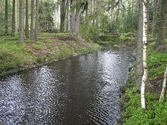
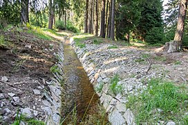
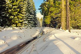
Pictures from the area

The Glatzener Pond
The ditch near the outflow from the Glatzener pond
About 2 km west of Prameny 1)
About 1 km north of Prameny 2)

About 1.5 km northeast of Prameny
.JPG)

.jpg)
.jpg)
.JPG)
1) The stone slabs, which protect the edge area from erosion , are clearly visible .
2) The trapezoidal cross section is particularly clear here
Individual evidence
- ↑ a b c d Flossgraben cultural monument , accessed on July 6, 2017
- ↑ Plan rozvoje vodovodů a kanalizací. ( German planning of water and wastewater supply ) 2015, p. 8 ( PDF ; 698 kB).
- ↑ a b Rudolf Tomíček, Vladislav Podracký: City Guide Horní Slavkov. Město Horní Slavkov, Horní Slavkov 2008, p. 22 ( PDF ; 2 MB).
- ^ Friedrich Naumann: Georgius Agricola, 500 years: Scientific conference from March 25 to 27, 1994 in Chemnitz . Birkhäuser, Basel, 1994, ISBN 978-3-03-487159-4 , p. 42.