
Dynów (rural municipality)
| Gmina Dynów | |||
|---|---|---|---|

|
|
||
| Basic data | |||
| State : | Poland | ||
| Voivodeship : | Subcarpathian | ||
| Powiat : | Rzeszów | ||
| Geographic location : | 49 ° 49 ′ N , 22 ° 14 ′ E | ||
| Height : | 260 m npm | ||
| Residents : | see Gmina | ||
| Postal code : | 36-065 | ||
| Telephone code : | (+48) 16 | ||
| License plate : | RZA | ||
| Economy and Transport | |||
| Street : | Przemyśl - Rzeszów | ||
| Rail route : |
Przeworsk – Dynów Bachórz railway station |
||
| Next international airport : | Rzeszów-Jasionka | ||
| Gmina | |||
| Gminatype: | Rural community | ||
| Gmina structure: | 9 localities | ||
| 9 school offices | |||
| Surface: | 119 km² | ||
| Residents: | 6913 (Jun. 30, 2019) |
||
| Population density : | 58 inhabitants / km² | ||
| Community number ( GUS ): | 1816052 | ||
| administration | |||
| Wójt : | Krystyna Teresa Sówka | ||
| Address: | Księdza Józefa Ożoga 2 36-065 Dynów |
||
| Website : | www.gminadynow.pl | ||

The Gmina wiejska Dynów is a rural municipality in the powiat Rzeszów of the Subcarpathian Voivodeship in Poland , the seat of the municipality is the city of Dynów ( German : Dünhof ), which does not belong to the Gmina. The Gmina has an area of 119 km² and 6913 inhabitants (as of June 30, 2019).
structure
The following nine localities with school administration offices belong to the rural municipality of Dynów:
- Bachórz
- Dąbrówka Starzeńska
- Dylągowa
- Harta
- Laskówka
- Łubno
- Pawłokoma
- Ulanica
- Wyręby.
Architectural monuments
- Church św. Zofii in Dylągowa
- Church św. Mikołaja in Harta
- Funerary chapel in Dąbrówka Starzeńska
- Castle ruins in Dąbrówka Starzeńska
- Station building in Bachórz of the narrow-gauge railway Przeworsk – Dynów ..
Pictures of the architectural monuments

Church in Dylągowa

Church in Harta

Funerary chapel in Dąbrówka Starzeńska
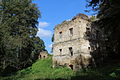
Castle ruins in Dąbrówka Starzeńska
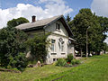
Station building in Bachórz


Web links
Commons : Gmina Dynów - collection of images, videos and audio files
- Rural Municipality Website (Polish)
Individual evidence
- ↑ population. Size and Structure by Territorial Division. As of June 30, 2019. Główny Urząd Statystyczny (GUS) (PDF files; 0.99 MiB), accessed December 24, 2019 .