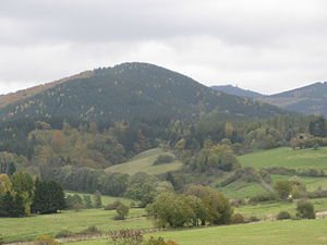
Acorn head
| Acorn head | ||
|---|---|---|
|
The Eichelnkopf near Herzberg am Harz, |
||
| height | 545.7 m above sea level NHN | |
| location | near Herzberg am Harz ; District of Göttingen , Lower Saxony ( Germany ) | |
| Mountains | resin | |
| Dominance | 1.12 km → Grimmberg | |
| Notch height | 63 m ↓ ridge northeast of the acorn head | |
| Coordinates | 51 ° 39 '36 " N , 10 ° 23' 41" E | |
|
|
||
The Eichelnkopf is a 545.7 m high mountain in the southwestern part of the Harz Mountains . It is located near Herzberg am Harz in the non-parish Harz region of the Lower Saxony district of Göttingen ( Germany ).
geography
location
The Eichelnkopf rises in the Harz Nature Park . Its summit is about 3.5 km east of Herzberg am Harz and 3.5 km north of the Herzberg district of Scharzfeld , 2.5 km southwest of the Großer Knollens ( 687.4 m ) and 0.9 km southwest of the middle corner ( 500.1 m ).
Natural allocation
In the natural spatial main unit group Harz (No. 38), in the main unit Upper Harz (380) and in the subunit Southern Upper Harz (380.8), the border of the natural areas Oderbergland (380.81) and Sieberbergland (380.82) runs over the Eichelnkopf. The landscape falls to the south-west into the natural area Herzberger Vorlandterrassen (376.25) and to the south-south-west into the natural area Scharzfelder Zechsteinhügel (376.27), which is part of the main unit group Weser-Leine-Bergland (37) and its main unit south-western Harz foreland (376) to the subunit Osterode- Herzberger Vorland (376.2) belong.
geology
On the eastern slope of the Eichelnkopf there is an isolated occurrence of dark slate from the Silurian , which is one of the oldest rocks in the entire Harz.
Protected areas and forest cover
Parts of the Harz landscape protection area (district of Göttingen) ( CDDA no. 321403; 2000 designated; 300.112 km² in size) lie on the Eichelnkopf . The mountain is partly overgrown with spruce and partly with beech trees. In 1596 there were predominantly beeches, in 1630 young oaks, birches and beeches.
hike
There is a hiking trail that leads from the north to the Eichelnkopf. The last 300 m below the summit, with an incline of up to 34%, are a special challenge for mountain bikers. On the southern slope of the mountain, a hiking trail leads past the 300-year-old owl oak .
swell
- Topographic map Bad Lauterberg , No. 4328, M = 1: 25,000 (TK25), ISBN 9783894354237
- Geological map Harz , M = 1: 100,000, published by the State Office for Geology and Mining Saxony-Anhalt in cooperation with the Lower Saxony State Office for Soil Research, Halle 1998, ISBN 3-929951-20-7
Individual evidence
- ↑ a b Mountain height according to the topographic map Bad Lauterberg , No. 4328, M = 1: 25,000 (TK25), ISBN 9783894354237
- ↑ Jürgen Spönemann: Geographical Land Survey: The natural spatial units on sheet 100 Halberstadt. Federal Institute for Regional Studies, Bad Godesberg 1970. → Online map (PDF; 4.7 MB)
- ^ Kurt Mohr, Geology and Mineral Deposits of the Harz, 2nd edition, Stuttgart 1993, ISBN 3-510-65154-5 , p. 19
- ↑ Map services of the Federal Agency for Nature Conservation ( information )
- ↑ Ina Begemann: Palynological investigations on the history of the environment and settlement in the southwestern Harz foreland (including geochemical findings) ( Memento from October 12, 2012 in the Internet Archive ), dissertation for obtaining the doctorate of the mathematical and natural science faculties of the Georg August University Göttingen, Göttingen 2003, p. 47 (PDF; 2.9 MB)

