
Ice box spike
| Ice box spike | ||
|---|---|---|
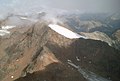
 Eiskastspitze from the east |
||
| height | 3371 m above sea level A. | |
| location | Tyrol , Austria | |
| Mountains | Ötztal Alps | |
| Dominance | 1.22 km → Bliggspitze | |
| Notch height | 201 m ↓ Bliggjoch | |
| Coordinates | 46 ° 55 '49 " N , 10 ° 47' 30" E | |
|
||
| First ascent | probably 1853 during the military survey | |

The Eiskastenspitze is a 3371 m above sea level. A. high mountain of the rear Kaunergrat , a mountain range of the Ötztal Alps . It is one of the highest and most powerful mountains on the rear Kaunergrat and is connected to its higher neighbor - the Bliggspitze - by a jagged ridge. The mountain slopes down on all sides with steep flanks. The impressive, extremely steep north face is difficult to climb. The mountain is crowned by a large firn plateau , at the north-western end of which the summit rises. To the south, the basin of the Middle Eiskastenferner connects to the mountain flank. The view from the Eiskastenspitze includes not only the rear Kaunergrat but also the highest peaks of the Weißkamm . In ancient times the mountain was also called Äussere Blickspitze due to its proximity to the higher Bliggspitze .
rise
The normal route leads from the Taschachhaus on the Hüttenweg down to the Sexegertenbach, on a bridge over the brook and on the marked path up the slopes. At the junction of the Fuldaer Höhenweg at the Eiskastenbach, it rises, following the Offenbacher Höhenweg , upwards over moraine slopes in the direction of the Vorderen Köpfle ( 2740 m ), a conspicuous, table mountain -like head. This is passed to the south and you reach a wide scree kar , at the other end of which the mountain rises. The path leads through the cirque towards the Mittlerer Eiskastenferner and to the right edge of the glacier, then up over the block slopes until it reaches a strip of scree between the hanging glacier and the steep mountain flank. On this strip it runs west up to the flat glacier surface and on the ice on the right into the uppermost glacier basin. Now the path turns north and climbs over firn and rubble towards a steep gully, in which it rises until it becomes very steep. There it leads out to the left and follows the footsteps further upwards, roughly parallel to the channel and after reaching a band that runs transversely upwards through the steep rock, up over the steep and in places poorly grip slabs. Under a slight overhang one reaches lighter rock again, over which one soon reaches the firn hood. On the left edge over the firn towards the summit head and slightly over blocks and rubble to the summit with Steinmann and Stange.
photos

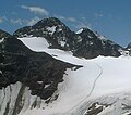
On the firn hood
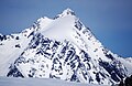
Eiskastenspitze from the south, from the Bliggspitze
Eiskastenspitze from the north (with north wall)
Eiskastenspitze from the southeast


Literature and map
- Walter Klier : Alpine Club Guide Ötztal Alps . Bergverlag Rudolf Rother , Munich 2006. ISBN 3-7633-1123-8
- Ludwig Obersteiner: Guide through the Ötztal Alps . Reichenstein-Verlag, Vienna 1925
- Alpine club map sheet 30/3, 1: 25,000, Ötztal Alps, Kaunergrat . ISBN 978-3-928777-41-4
Web links
Individual evidence
- ↑ Clem Clements, Jonathan de Ferranti, Eberhard Jurgalski , Mark Trengove: The 3000 m SUMMITS of AUSTRIA - 242 peaks with at least 150 m of prominence , October 2011, p. 8. Height of the reference chart according to: Walter Klier: Alpenvereinsführer Ötztaler Alpen, Munich 2006, RZ 1781.
- ↑ Federal Office for Metrology and Surveying Austria: Eiskastenspitze on the Austrian Map online (Austrian map 1: 50,000) .
- ↑ H.Hess / L.Purtscheller: The high tourist in the Eastern Alps , Vol. I, Leipzig 1903, supplement card Inner Ötztal Alps