Elsenborn
| Elsenborn | ||
|---|---|---|
|
|
||
| State : |
|
|
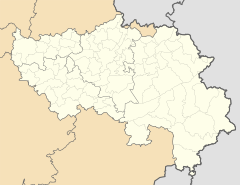
| Region : | Wallonia | |
| Province : | Liege | |
| District : | Verviers | |
| Municipality : | Butgenbach | |
| Coordinates : | 50 ° 27 ' N , 6 ° 13' E | |
| Residents: | 941 pop. | |
| Height: | 635 m | |
Elsenborn is a village in Belgium and has been part of the municipality of Bütgenbach in the German-speaking Community since the municipal merger in 1977 . The place has 941 inhabitants (2019).
location
Elsenborn is located on the edge of the High Fens about three kilometers north of Bütgenbach. The closest German town is Kalterherberg to the north . The direct road connection there, formerly part of the Aachen-Trierer Landstrasse, is closed. With a height of around 635 m , it is the highest district in the municipality. The national road 647 connects the place to the regional traffic.
history
The name of the place first appeared in 1352, when Beatrix von Elsenborn married Heinrich von Steffenshausen. The castle house has gone. In Bütgenbach's fireplace directory from 1501 the place had 18 houses. The first chapel was built in 1688. It was in today's cemetery. The current church dates from 1840.
The area belonged to the Duchy of Luxembourg when it came under French rule in 1795, it was given to Prussia as a result of the Congress of Vienna in 1815 and from then on belonged to the Malmedy district in the administrative district of Aachen. After the First World War , the borders were redrawn as part of the Versailles Treaty and Elsenborn fell to Belgium on January 10, 1920.
Until the municipal merger in 1977, Elsenborn was an independent municipality, to which the towns of Küchelscheid , Leykaul and Nidrum also belonged.
tourism
- Herba Sana one of the most important publicly accessible medicinal herb gardens in Europe.
- Sports, ski and cultural center Herzebösch
Military training area
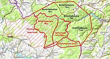
To the north of Elsenborn there is a 28 km² military training area, which was created in 1895 for the VIII Prussian Army Corps , at a time when Elsenborn was part of the Prussian Rhine Province and thus part of the German Empire . It has been under Belgian military administration since 1920, only interrupted from 1940 to 1945 when the German Wehrmacht occupied the place. It initially served artillery and cavalry units and was later made accessible to all branches of service. Nowadays the military training area is used by Belgian and foreign armies and the like. a. used within the framework of joint maneuvers and by NATO soldiers who are being prepared for their peacekeeping operations in Asia, Africa, the former Yugoslavia and other trouble spots around the world.
The population from the surrounding area has benefited significantly from the establishment of the practice area since the beginning, as it allowed the shops, bars and service providers in the village to experience a considerable boom and numerous civilian jobs were created in the camp. In addition, the infrastructure inside and outside the village has been improved and the community has been compensated with a considerable amount of compensation for each day of closure.
Large areas of the military training area are also designated as Natura 2000 protected areas under the Fauna-Flora-Habitat Directive and are subject to appropriate observation and care.
literature
- Leo Leyens, Léon Renardy, Leo Wintgens: ELSENBORN, camp and military training area (1894–2014). Helios Verlag, Aachen 2015, ISBN 978-3-86933-135-5 .
Web links
Individual evidence
- ↑ Population per village. Bütgenbach municipality, January 2, 2019, accessed on April 29, 2019 .
- ^ Elsenborn - history. Bütgenbach municipality, accessed on April 29, 2019 .


