1988 Spitak earthquake
Location of the epicenter in Armenia |
The 1988 Spitak earthquake was an earthquake in the Caucasus that hit the area around the northern Armenian city of Spitak (today's Lori Province ) in what was then the Armenian SSR of the Soviet Union on December 7, 1988 . With an estimated number of at least 25,000 dead and up to a million homeless, it is one of the worst earthquakes in decades. As a result, it came for the first time during the Cold War to humanitarian relief western organizations in the Soviet Union.
geology
The Caucasus is a folded mountain range that was created when the Eurasian and Arabian tectonic plates collided . Since the latter is being pushed northwards by an eastward drift of the African plate , the mountains continue to fold up to this day, and the resulting tensions are often discharged in earthquakes, as was the case with the Schemacha earthquake in 1902.
The quake

|

|
|
|
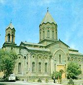
The Church of the Redeemer in Gyumri before 1988
|
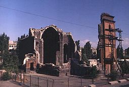
The rubble of the Church of the Redeemer after the earthquake
|
The earthquake struck the region on December 7, 1988, a Wednesday, at 11:41 a.m. local time (7:41 a.m. UTC ). It had a magnitude of 6.9 on the moment magnitude scale , the epicenter was about 18 kilometers northwest of Spitak. Compared to other earthquakes of similar magnitude , it caused devastating damage, on the one hand because the hypocenter was only about five kilometers below the earth's surface, and on the other hand because the structural fabric of the buildings in Spitak and the surrounding villages was extremely poor. Four minutes after the main quake, an aftershock with a magnitude of 5.8 shook the region; in the following months, further aftershocks up to a maximum magnitude of 5.0 were registered.
The consequences
The cities of Spitak , Leninakan (today Gyumri ), Kirovakan (today Vanadzor ) and Stepanawan as well as a number of surrounding villages were particularly affected . Spitak was so badly destroyed that the city was abandoned after the earthquake and completely rebuilt in a slightly different location. Some of the buildings in the “new” Spitak were built in the style of the nations that made the reconstruction possible. The information on the number of victims varies widely. Often 25,000 deaths are mentioned, while other sources report significantly higher numbers. Nevertheless, around 15,000 people were rescued from the collapsed buildings in the first hours after the quake. After the quake there were statements that if the earth had shaken just a few minutes later, the number of victims would have been significantly lower, as there would have been a break in schools and factories and many people would have survived outdoors, who would now have died in the collapsed buildings came.
In addition to the reasons mentioned, there were other factors that made the number of dead and homeless so high. Winter temperatures prevailed at the time of the catastrophe, as a result of which people who survived the actual quake froze to death outdoors. It is also reported that in Spitak and the surrounding villages up to 80 percent of the medical staff were killed in the collapsed hospitals and medical practices and that medical care was therefore not available.
Apart from the number of victims and the financial damage, which was estimated at around 14 billion US dollars, a fault in the landscape was found as a result of the earthquake, which was up to 1.6 meters high and stretched eight to eight kilometers.
Another consequence of the quake was the closure of the only nuclear power plant in Armenia , located about 90 kilometers from the epicenter of the quake , which remained shut down for seven years.
International aid
After the news of the disaster, the Soviet head of state Mikhail Gorbachev returned from a state visit to the United States and visited the earthquake area. In view of the extent of the damage, Gorbachev asked the United States for humanitarian aid after a few days, regardless of the Cold War , for the first time after the Second World War . As a result, several western states in the Caucasus provided aid, including the Federal Republic of Germany and Switzerland . Aid also came from the Soviet Republic of Azerbaijan , although relations between the neighbors were strained in both republics due to the conflict over Nagorno-Karabakh and related pogroms and expulsions.
Another form of help has been projects such as Rock Aid Armenia : The Earthquake Album (a benefit record that was made by numerous English-speaking rock musicians and released in 1990) and Pour toi Arménie (a song by the Franco-Armenian singer-songwriter Charles Aznavour , on which more than 80 mostly French artists participated).
In Gyumri, various institutions testify to the international aid. But in 2016 people were still living in “makeshift” containers.
Web links
Remarks
- ↑ The indication “strength 10-11”, which can be found on the Internet, is related to the earthquake scale used in the Soviet Union at that time (see Medvedev scale ), which differs from the scales commonly used in the West.
Individual evidence
- ↑ Soviet Union When the Earth Shook Article in Time magazine , December 19, 1988
- ↑ a b c d National Geophysical Data Center (NGDC)
- ^ Homepage of the Youth Red Cross Baden-Württemberg ( Memento from July 21, 2010 in the Internet Archive )
- ↑ Homepage of the ORF ( Memento from May 29, 2007 in the Internet Archive )
- ↑ The earth lay in labor pangs . In: Der Spiegel . No. 51 , 1988, pp. 123-124 ( Online - Dec. 19, 1988 ).
- ^ Information from Colorado State University
- ↑ Photo: RIA Novosti archive, image # 8968 / Alexander Makarov / CC-BY-SA 3.0
- ↑ 1988 Spitak earthquake and plane crash. In: Alumniportal Azerbaijan. June 30, 2019, accessed June 30, 2019 .
- ↑ Tigran Petrosyan: Inactive Government of Armenia: Survival in a Cardboard Box . In: The daily newspaper . September 30, 2016 ( taz.de [accessed November 17, 2018]).
Coordinates: 40 ° 59 ′ 0 ″ N , 44 ° 11 ′ 0 ″ E


