Etosha pan

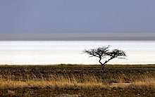
The Etosha Pan (formerly also Etosa or Etosha Pan ) is the bottom of a periodically filled lake in northern Namibia and part of the Etosha National Park . The name Etosha has its origins in the Ovambo language and means something like "large white square". Together with the Cuvelai system and Lake Oponono, it forms a special wetland area in accordance with the Ramsar Convention in the natural area of the northern part of the country .
The pan extends over 4760 square kilometers with a maximum length of 120 kilometers and a maximum width of 55 kilometers. The pan lies at around 1000 m above sea level and belongs to the Kalahari Depression, which extends over large parts of Botswana , eastern and northern Namibia.
The Etosha pan has been on Namibia's tentative list for nomination as Namibian World Heritage since the end of October 2016 .
Discovery by Europeans
Although the area of today's national park was known to the local tribes - Ovambo , Herero, and San - for centuries as a pasture and hunting ground, it wasn't until 1851 that the Swedish explorer John Charles Andersson and the English scientist Francis Galton , a cousin of Charles Darwin , were the first Europeans in this area. In his travel and research report “Lake Ngami ”, Andersson wrote: “During the first day of travel we crossed a huge depression, called Etosha, which covered a salt crust and whose tree-lined edge was clearly visible. In Africa such comparable places are often called “ salt pans ”. The surface consists of greenish loam with scattered small chunks of sandstone of a purple color. In some rainy seasons, the Ovambo told us, the area was flooded and then looked like a lake; but now it was completely dry and the ground was heavily saturated with salt. "
The two also stopped at Fort Namutoni .
In the 1860s, the Dorsland trekkers (Durstland tractors) from Transvaal , South Africa , came through here on their way to Angola .
In 1876 the American traveling salesman Gerald McKiernan roamed South West Africa, came to the Etosha Pan after crossing the Namib and discovered the spring in what is now Okaukuejo .
From 1884 to 1914 the Etosha pan was part of the German Southwest Africa colony .
geology
The Etosha pan is a salt flat and has a characteristic white and greenish surface. In contrast to the smaller side pans, the Etosha pan does not have the characteristics of a classic salt pan.
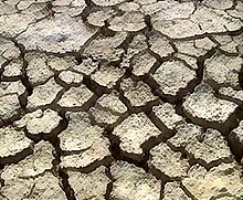
The depression was created by tectonic activities 2-4 million years ago. 4–10 million years ago water collected there and formed an inland lake ( Ekuma Lake ) through various tributaries, which are no longer detectable today . By changing the course of the river - it is believed that the Kunene also fed the lake in the past - the lake dried up and left what is now the lime and salt pan. The year-round sparse vegetation gives the Etosha pan its characteristic color as described above. Outside the actual pan there are numerous natural water sources through artesian springs (water is pumped to the surface with pressure), the groundwater table or contact sources (formations of different permeability meet).
In particularly rich rainy years, the Etosha pan fills approx. 10 cm high and then attracts thousands of flamingos , waders and other water birds that also breed here. In heavy rainy years the water also feeds some tributaries of the Kunene, e.g. B. the Ekuma and the Oshigambo in the northeast and the Omuramba Ovambo in the east. The average precipitation from October to April is approx. 250-450 mm, depending on the location. The water then has a salt content that is twice as high as that of sea water.
The pan was last completely full in 2008.
Trivia
The Etosha area became famous for the monumental shots in the 1968 Stanley Kubrick film 2001: A Space Odyssey .
literature
- Helmut Hartl: NAMIBIA - Excursion of the NWV August 25 - September 10, 1994
- Daryl and Sharna Balfour: Etosha - Natural Paradise in Africa . Franckh-Kosmos, Stuttgart 1992, ISBN 3-440-06499-9 .
- Martin HT Hipondoka: The Development and Evolution of Etosha Pan, Namibia . Würzburg 2005, dissertation at the Bavarian Julius Maximilians University of Würzburg, online .
- MW book: Cenozoic climate and environmental change in Etoscha / Northern Namibia - Investigations into the climate sensitivity and geomorphodynamics of a semi-arid landscape in southern Africa . Habilitation, Regensburg 1993.
- MW Buch, M. Lindeque, H. Beugler-Bell, W. du Plessis, Ch. Trippner: Environmental Change in the Etosha National Park, Northern Namibia. The Research-Cooperation-Project between the Etosha Ecological Institute, Okaukuejo / Republic of Namibia and the Department of Geography at the University of Regensburg / FR of Germany. Aims, Activities and First Results. Report submitted to the Deutsche Forschungsgemeinschaft (DFG) and the Gesellschaft für Technische Zusammenarbeit (GTZ). 1993/1994, Regensburg / Okaukuejo, self-published. Vol. I-V.
Web links
- United Nations , World Heritage Center: Etosha Pan . at www.whc.unesco.org (English)
Individual evidence
- ^ Geological Attraction Etosha. Ministry of Mines and Energy, Namibia, 2007 ( Memento of the original from March 9, 2014 in the Internet Archive ) Info: The archive link was inserted automatically and has not yet been checked. Please check the original and archive link according to the instructions and then remove this notice. Retrieved June 28, 2013
- ↑ Etosapfanne, in: Heinrich Schnee (Ed.): Deutsches Koloniallexikon . Volume I, Quelle & Meyer, Leipzig 1920, p. 592.
- ^ Etosha Pan has water for first time in decade. The Namibian, April 23, 2008.
Coordinates: 18 ° 47 ′ S , 16 ° 16 ′ E


