Höllberg (Westerwald)
| Höllberg | ||
|---|---|---|
|
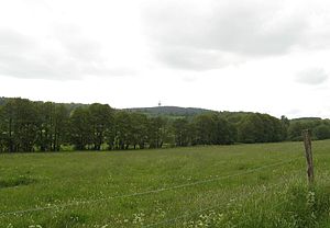
View of the Höllberg from Driedorf |
||
| height | 642.8 m above sea level NHN | |
| location | at Hohenroth ; Lahn-Dill-Kreis Hessen ( Germany ) | |
| Mountains | Westerwald | |
| Coordinates | 50 ° 38 '42 " N , 8 ° 9' 0" E | |
|
|
||
The Höllberg (also called Höllkopf ) is a mountain in the High Westerwald and at 642.8 m above sea level. NHN in front of Auf der Baar and Bartenstein, the highest Hessian mountain in the low mountain range Westerwald , which with the Rhineland-Palatinate Fuchskaute maximum 657.3 m above sea level. NHN is high.
Geographical location
The Höllberg rises in the area of the municipality of Driedorf , 2.8 km northwest of the core town. To the north of the mountain is the district of Heisterberg with the Heisterberger Weiher recreation area , to the south is the district of Mademühlen , and to the west is the district of Hohenroth . From the last-mentioned village it is a few hundred meters to the state border with Rhineland-Palatinate .
leisure
The summit of the Höllberg offers good prospects, and in winter there is the possibility of skiing on a short but steep slope on the mountain . A ski lift is available.
Telecommunication tower Höllberg
On the Höllberg the 108-meter telecommunications tower is Höllberg ( type tower type FMT 11).
Frequencies and Programs
Analog radio (FM)
In the case of directed radiation, the main radiation directions are given in degrees in the antenna diagram.
|
Frequency (MHz) |
program | RDS PS | RDS PI | Regionalization |
ERP (kW) |
Antenna pattern round (ND) / directional (D) |
Polarization horizontal (H) / vertical (V) |
|---|---|---|---|---|---|---|---|
| 106.8 | Hit Radio FFH |
_FFH-GI_ , HITRADIO / ___FFH__ 1) 2) |
D668 (regional), D368 |
Central Hesse / Giessen | 30th | D (170 ° -280 °) | H |
- 1) Sometimes dynamic with program information, music track information or web addresses
- 2) Dynamic, partly with news
Individual evidence
Web links
Winter sports in the municipality of Driedorf… Höllkopf ski area , on driedorf.de


