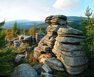
Festungshübel
| Fortress Pevnost |
|
|---|---|
| Basic geotopic data | |
| Geotope type | Granite outcrop |
| Terrain height | 1012 m |
| Size (L × W × H) | L x W x 7m |
| location | Královéhradecký kraj , Czech Republic |
| Geological unit (s) | Silesian ridge → Giant Mountains |
| Municipality / city | Spindlermühle ( Špindleruv Mlýn ) |
| Coordinates | 50 ° 45 '12 " N , 15 ° 36' 15" E |
Festungshübel is the German name for a rock formation made of granite , almost halfway between the western and eastern half of the Silesian Ridge of the Giant Mountains in the Czech Republic .
Names
Fortress is another German name and has its equivalent in the Czech Pevnost . In fact, you can be reminded of a rock castle that guards the Elbe breakthrough high above the confluence of the Weißwasser into the young Elbe .
location
The granite rocks up to 7 meters high are located on the southern slope of the border ridge ( Hraniční hřeben ) at an altitude of 1012 meters above sea level above the Bear Ground ( Medvědí důl ). The area belongs to the Krkonošský národní park (KRNAP) national park , but the protection regulations of zone III allow climbing the rocks. Although they barely tower above the surrounding treetops, it is worth the effort, because the reward is a 360-degree all-round view ...
- ... in the west on the Medvědín (Schüsselberg), the Goldhöhe and the Labský důl (Elbgrund)
- ... in the east to the Kleine Balaclava , the area of the Siebengrund and the Kozí hřbety (back of the goat), behind it the Schneekoppe
- ... in the south to the mountain community Špindlerův Mlýn (Spindleruv Mlyn) and the Elbe breakthrough, which is about 5 km to the north .
- ... in the north on the Silesian Ridge with Hohem Rad , Mannsteinen , Mädelsteinen and Spindlerpass
Emergence
Like all the other rock groups along the main ridge, the current shape is the result of millennia of erosion processes . After kilometer-thick layers of slate and sandstone were removed during the Tertiary , the granite pluton of the Giant Mountains came to the surface. During the last ice age , frost weathering caused ever deeper fissures along natural break lines. These occur at right angles in the so-called orthogonal fracture system and lead to the weathering of wool sacks typical of the area . Together with the phenomenon known as “soil flow” , which managed to transport smaller boulders, gravel and sand down into the valley, the rocks finally remained standing as granite outcrops , in layman's terms isolated. Geomorphologically the rock formation on the rating goal are assigned (eponymous are said rock towers in gate Dartmoor / England ).
tourism
Only about 500 m as the crow flies (about 1.2 km on foot) there is a bus stop at the Davidsbauden ( Davidovy boudy ) that connects Spindleruv Mlyn with the Spindlerpass. Nearby, a wide forest path leads through the spruce forest slightly uphill directly to the fortress. If you do not want to take the bus, follow the yellow-marked hiking trail from the center of Spindleruv Mlyn over the Mädelsteg intersection in the direction of Davidsbauden and also turn left above the bus stop.
In the immediate vicinity there are other rock groups of the same origin, which can be connected to one another via an extended hike. The Vogelstein ( Ptačí kámen ) can be found 300 meters above sea level. Another 100 meters higher, on the ridge of the border ridge, the Mädelsteine and Mannsteine form its double peaks.
Individual evidence
- ↑ Rock towers (Giant Mountains season)
- ↑ Bus Info ( Memento of the original from March 5, 2016 in the Internet Archive ) Info: The archive link was inserted automatically and has not yet been checked. Please check the original and archive link according to the instructions and then remove this notice.
