Wrinkled tip
| Wrinkled tip | ||
|---|---|---|
|
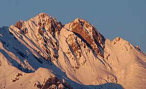
Fiechterspitze (left) and Mittagspitze (right) from the east ( St. Georgenberg ) |
||
| height | 2299 m above sea level A. | |
| location | Tyrol , Austria | |
| Mountains | Hinterautal-Vomper chain , Karwendel | |
| Dominance | 0.12 km → midday peak | |
| Notch height | 36 m ↓ lunch slot | |
| Coordinates | 47 ° 22 '3 " N , 11 ° 38' 41" E | |
|
|
||
| rock | limestone | |
|
Mittagspitze (left) and Fiechterspitze (right) from the south |
||
The Fiechter peak , also Fiechter Spitz , is 2299 m above sea level. A. high mountain in the Karwendel in Tyrol .
Location and surroundings
The Fiechterspitze is the most easterly pronounced summit of the Hinterautal-Vomper chain . The summit structure of the Fiechterspitze has a steep and rocky character, underneath are steep and rugged alpine mats , followed by extensive mountain pine belts .
Neighboring mountain in the west is 2332 m above sea level. A. high noon peak, from which the Fiechter peak is separated by the noon notch . In the north, the Fiechterspitze drops steeply into the Stallental . In the east, the Hinterautal-Vomper chain descends over the Hirschkopf (approx. 1960 m above sea level ) and the Vomper Joch into the Inn valley . In the south-east lies Vomp with the district Fiecht , after which the mountain is named, in the Inn valley . The Vomper Loch runs to the south and southwest .
Summit cross
The summit cross was erected in 1959.
Approaches
From Vomperberg in the south and from Fiecht, several paths and marked hiking trails lead through the southern flank of the Fiechterspitze to the Hirschkopf in the east. From there, a marked increase, which, however, runs climbing in difficulty III requires, on the east ridge to the summit. A total of about five hours are estimated for the ascent.
Another path leads from the Mittagspitze to the west, which can be reached via the Schrofen area on the south side, with difficulty II +, to the Fiechterspitze. The transition to the noon peak has difficulty II.
Web links
Individual evidence
- ↑ a b Heinrich Klier , Fritz March: Alpine Club Guide Karwendel Mountains . Ed .: German Alpine Association , Austrian Alpine Association , Alpine Association South Tyrol . 11th edition. Bergverlag Rother, Munich 1978, ISBN 3-7633-1208-0 , p. 403 .


