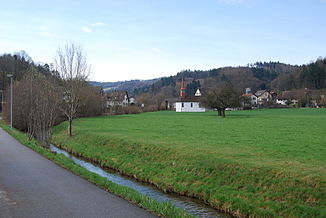
Fisibach (river)
|
Fisibach Holzwisenbach |
||
|
Fisibach near Fisibach |
||
| Data | ||
| Water code | CH : 694 | |
| location | Switzerland | |
| River system | Rhine | |
| Drain over | Rhine → North Sea | |
| source | in the pasture area on the eastern slope of Egg 47 ° 30 '26 " N , 8 ° 26' 23" E |
|
| Source height | 523 m above sea level M. | |
| muzzle | northwest of Kaiserstuhl in the Rhine Coordinates: 47 ° 34 ′ 28 " N , 8 ° 24 ′ 22" E ; CH1903: 672 800 / 269 751 47 ° 34 '28 " N , 8 ° 24' 22" O |
|
| Mouth height | 333 m above sea level M. | |
| Height difference | 190 m | |
| Bottom slope | 19 ‰ | |
| length | 10 km (with the longest source stream) | |
| Catchment area | 16.39 km² | |
| Discharge at the estuary A Eo : 16.39 km² |
MQ Mq |
170 l / s 10.4 l / (s km²) |
| Communities | Steinmaur , Bachs , Fisibach | |
| Residents in the catchment area | around 1030 | |
The Fisibach is a ten-kilometer left tributary of the Rhine in the Swiss cantons of Zurich and Aargau . It flows through the Bachsertal and drains an area of around 16.4 square kilometers.
geography
course
The Fisibach arises from three source streams on the eastern slope of the Egg , which unite at the Lütnantsholz to form the Holzwisenbach , which after a short run becomes the Fisibach when it exits the Eggwald . It flows mainly in a north-westerly direction through the Bachs and Fisibach and flows into the Rhine after ten kilometers near Kaiserstuhl . Right next to its mouth there is an infantry bunker "Fisibach-Bleiche" of the Swiss Army in the Rhine .
Tributaries
In the canton of Zurich:
- Chüebrunnengraben ( right )
- Hochrütibach or Dorfbach (Bachs) ( left )
- Wissikerbächli ( left )
- Stampfibach ( left )
- Flüenenhölzlibach ( right )
- Heinispitzbach ( left )
- Neumülibach ( right )
- Rainbach ( left )
- Balmbach ( left )
- Lochbach ( left )
- Waldhuserbach ( left )
In the canton of Aargau:
- Waldhuse ( left )
- Bachtobel ( right )
- Tychgrabe ( left )
Individual evidence
- ↑ a b individual records of the geographic information system of the canton of Zurich
- ↑ a b Geoserver of the Swiss Federal Administration ( information )
- ↑ a b Modeled mean annual discharge. In: Topographical catchment areas of Swiss waters: sub-catchment areas 2 km². Retrieved August 30, 2017 .
Web links
Course of the Fisibach on the geoserver of the Swiss federal administration

