Polders

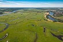
A polder is a diked, low-lying area near water. There are two opposing meanings in relation to flood protection .
Classic meaning
In the classic Dutch meaning, especially in the area around the Ems estuary and on the lower Oder, also used in German, in Normandy also in French, a polder is an area that is itself protected from flooding by dykes . In most of these polders, the water level of neighboring larger bodies of water (sea or rivers) is often or permanently above ground level. That is why the water from the polder's drainage ditches has to be pumped over or through the dike , in today's times mostly with engine power, in pre-industrial times with wind power . The groups of windmills on the dykes of the Rhine Delta, a symbol of the Netherlands, are old wind pumps . In Schleswig-Holstein the classic polders are known as Koog . The word Groden, which is common in Lower Saxony , actually refers to the foreland of the dike, but was retained as a name in many places after the areas were dyed.
Examples of well-known polders:
- In the Netherlands and Flanders , entire areas of land are diked and form a typical polder landscape. The best known example are the Zuiderzeewerke , which transformed the Zuiderzee into the IJsselmeer .
- The Oderbruch has been a polder since the dike in the 18th century led the Oder , whose water level is now higher than the bottom of the Oder lowlands, past the eastern edge of this lowland.
- The polder landscape of the island of Schokland in the Netherlands was included in the UNESCO World Heritage List in 1995, as this cultural landscape is particularly worthy of preservation because of its "extraordinarily universal value".
Flood polder / flood protection polder
A flood polder is a retention area that can be flooded in a targeted manner during river floods in order to temporarily reduce the flow of water in downstream sections of the river and thereby reduce the peak of a tidal wave. Such polders are subject to usage restrictions, such as a building ban. They are separated from the river bed as well as from neighboring, more intensively used areas by dikes.

The dikes leading to more intensively used neighboring areas prevent them from being flooded when the polder is flooded. Dykes leading to the waterway improve the usability of the polder area by preventing the polder from being flooded at low floods that do not pose a threat in subsequent sections of the river. They enable the water withdrawn from the river to be retained longer than in a naturally flooded flood plain. Such polders are primarily created for flood protection in large cities and narrow valleys in spacious valley sections above, for example on the Upper Rhine near Ingelheim am Rhein .
In the case of less large bodies of water, flood polders are designed as retention basins - when empty if necessary , as in the Leinetal between Northeim and Einbeck - Salzderhelden . Here a dam, through which the river normally flows unhindered through an open gate at the base, blocks the river valley. During floods, the tidal wave is dammed here and the runoff is regulated to a level that is compatible with the lower reaches.
A distinction is made between uncontrolled and controlled polders. In the case of an uncontrolled polder, the retention basin fills up when a height defined by the dam is exceeded. If this filling process takes place at the time of the maximum of the flood wave, such a polder can bring about a significant reduction in the flood peak, depending on its size. However, if the flood wave passes the polder area at a point in time when the polder is already full, significantly less water can be drained off and the retention effect is reduced. With a controlled polder, the relief can be tailored precisely to the maximum of the flood wave. However, this requires an early and as precise as possible prediction of the course of the flood.
Polder in landfills
In waste technology, polder refers to a pit into which waste is brought to be deposited, or a corresponding dumping of waste in a landfill . The parallel to the polder in hydraulic engineering is explained by the fact that a landfill is usually (often invisible) diked in order to collect and clean the runoff from it.
Web links
- Water retention on agricultural land from the perspective of water management . (PDF) Bavarian State Institute for Agriculture, comparison of water retention by relocating dykes - uncontrolled - controlled flood polders; Retrieved June 15, 2013
- Photos of Dutch polders
- Salzderhelden flood retention basin
Individual evidence
- ↑ René Hobracht: measures for a future-oriented flood protection: Taking into account the risk from Elbe flood areas in the Prignitz . Grin Verlag, 2010, ISBN 978-3-640-69563-8 ( Google Books )
