
Forstbach (Ruhr)
| Forstbach | ||
 The Forstbach, looking west |
||
| Data | ||
| Water code | DE : 276 9932 | |
| location | North Rhine-Westphalia , Germany | |
| River system | Rhine | |
| Drain over | Ruhr → Rhine → North Sea | |
| source | In Mülheim an der Ruhr 51 ° 24 '17 " N , 6 ° 55' 46" E |
|
| Source height | 108 m above sea level NHN | |
| muzzle | In Mülheim in the Ruhr Coordinates: 51 ° 24 '12 " N , 6 ° 53' 46" E 51 ° 24 '12 " N , 6 ° 53' 46" E |
|
| Mouth height | 38 m above sea level NHN | |
| Height difference | 70 m | |
| Bottom slope | 24 ‰ | |
| length | 2.9 km | |
| Catchment area | 3.07 km² | |
| Big cities | Mülheim an der Ruhr | |
The Forstbach is an approximately 2.9 kilometers long right tributary of the Ruhr in the North Rhine-Westphalian city of Mülheim an der Ruhr in Germany .
It is the penultimate major tributary before the Ruhr flows 17.5 kilometers further into the Rhine .
course
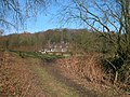
The Forstbach rises in the Mülheim district of Menden-Holthausen in the immediate vicinity of the Essen / Mülheim airfield in a swampy biotope of around 100 square meters , from which it is only channeled into the open as a stream beyond a courtyard entrance. It then flows through several small ponds. About 260 m down, it is piped again through some private properties over a length of about 80 m. Shortly above the animal shelter, it flows through a larger pond of around 1,000 square meters, until it reaches the Forstbachtal nature reserve with a natural stream bed after a total of 660 m below Horbeckstrasse, where a rain retention basin was created . Another 450 m downhill it flows through another approximately 1,000 square meter pond, followed by several abandoned trout ponds. The natural creek ends just above Mendener Straße at the Lierhaushof riding stables. There follows a piped stretch, and only the last 50 m does the brook flow, although enclosed, but open again, under the towpath into the Ruhr.
The Forstbachtal
The upper slope areas are largely populated with homesteads and cottages and are not accessible to the general public.
"In the central area, the main cemetery extends from the north down to the valley floor. In the west of the area there is a small species protection water in the area of a meadow. The forest stream itself is developed close to nature over long stretches. In the east there is a small abandoned quarry with about six meter-high cliff. the valley slopes are occupied predominantly by natural deciduous forests with differently developed shrub and herb layer. the floodplain is occupied largely by deciduous forests and grassland, it can be found repeated hybrid poplar -Forste. an alder shore wood increased along the lower reaches of the forest creek . On the upper reaches there are alder forests as well as smaller ash forests . Fallow meadows , butterbur , meadows and fatty willows , orchards and head trees divide the valley area. The Forstbachtal is of particular importance as a biotope network corridor in the arable landscape of the loess plateau . The proximity of the upper reaches to the Ruhr Valley i The isolated Rumbachtal is particularly noteworthy. The occurrence of the lobed shield fern ( Polystichum aculeatum ) , which is currently considered missing in the Westphalian Bight, and the giant horsetail ( Equisetum telmateia ), which is classified as endangered in North Rhine- Westphalia, is remarkable . The complex of near-natural biotopes and extensive cultural landscape elements make the area very attractive for recreation. "
The Forstbachtal is next to the Witthausbusch with the Kahlenberg and the Rumbachtal the most popular local recreation area in Mülheim right of the Ruhr.
Tributaries
The Forstbach has a few, not officially named, small tributaries on both sides.
photos

View of the Forstbach headwaters

Forstbach spring biotope

Pond above the animal shelter

Forstbachtal nature reserve

In the Forstbachtal
Side valley from the stone miner
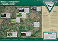
Information board in the Forstbachtal


Web links
- Mill history on www.muelheim-ruhr.de
- NSG "Forstbachtal" on www.muelheim-ruhr.de
Individual evidence
- ↑ a b German basic map 1: 5,000
- ↑ a b Topographical Information Management, Cologne District Government, Department GEObasis NRW ( Notes )
- ↑ NSG "Forstbachtal" on www.muelheim-ruhr.de