Fort Barrancas
| Fort Barrancas | ||
|---|---|---|
| National Register of Historic Places | ||
| National Historic Landmark | ||
| Historic District | ||
|
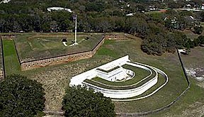
Fort Barrancas with connection battery |
||
|
|
||
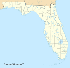
| location | Naval Air Station Pensacola , Escambia County , Florida | |
| Coordinates | 30 ° 20 '52 " N , 87 ° 17' 51" W | |
| Built | 1839-44 | |
| NRHP number | 66000263 | |
| Data | ||
| The NRHP added | October 15, 1966 | |
| Declared as an NHL | October 9, 1960 | |
Fort Barrancas (as it has only been known since 1839) was a US Army fortification and is located within the Pensacola Naval Air Station in Escambia County , Florida . It is located on an area belonging to the former township of Worrington. The task of the facility was, together with the sister forts Fort Pickens and Fort McRee, to block the entrance to Pensacola Bay and Pensacola , as well as to secure the Pensacola naval shipyard east of the fort.
Fortifications had been in the same place in front of the fort, which was built in 1839, since the 17th century.
The fort is listed as a National Historic Landmark and is administered by the National Park Service as part of the Gulf Island National Seashore .
The construction
It is actually only a triangular block of casemates, which becomes a square due to a protruding obtuse angle of the front and is located on a small hill. The floor plan sees the point at the back, the front with two facets and two flanks. The work is connected by a postern with the connection battery below and on the sea side and is surrounded on both sides by a dry ditch. It runs out at the reentrant angles to the faces in the embankment. A covered path leads to an advanced infantry base to the north. This was in the immediate vicinity of one of the foothills of the Grand Bayou and blocked access to the Pensacola Navy Yard on the shore.
history
At the same place there were already various fortifications, the first of which was a wooden fort called Fort San Carlos de Austria , built by the Spanish in 1689 . This fort was completely destroyed by French troops in 1719. In 1763 the English built an earthwork on the same site called the Royal Navy Redoubt, which received a gun battery made of masonry called the Bateria de San Antonio in front of the front from the Spaniards who returned in 1787 . At the same time the former English fort on the hill behind it was expanded and reinforced under the name Fuerte San Carlos de Barrancas (but it was still an earthwork with palisades). In the meantime, under British rule again, the British, who withdrew from General Andrew Jackson in 1814, completely demolished the building. After the area came under Spanish rule again, the fort was rebuilt in 1817. In 1821 the area finally came under US sovereignty. However, the construction of a massive brick fortification ( masonry ) in the course of the fortification of all important American seaports did not begin until 1839 . The upper fort was connected by a postern with the lower connection battery, which was repaired in 1838. The construction work was finished in 1844. Between 1845 and 1869, about 430 meters to the north, an advanced, brick-built infantry fort with a dry trench was built - the ( Advanced Redoubt ). The entire complex was given the final name Fort Barrancas when construction began .
The architect of the construction work was Joseph Gilbert Totten , the construction supervision was carried out by Major William Henry Chase . Almost all of the work was done by slaves.
Civil war
At the beginning of the American Civil War in 1860/1861 an infantry company of the US Army was under the command of Captain John H. Winder as a crew in Fort Barrancas. On January 8, 1861, the Confederate Colonel William Henry Chase, supported by a delegation of the Florida National Guard , requested the fort to surrender. As a sympathizer of the South (at the end of the war he was a general in the Confederate Army ), Captain Winder had already withdrawn from the troops, so that command was now with his deputy, Lieutenant Adam J. Slemmer . The latter rejected the request, with one of the first shootings (possibly the first exchange of fire at all) of the war taking place. Slemmer decided to use the vacant Fort Pickens opposite, as it was easier to defend. After rendering everything they couldn't take with them (about 10 tons of gunpowder and all cannons ) useless , the company took boats to Santa Rosa Island around midnight .
Confederate infantry and artillery from Alabama , Louisiana and Mississippi occupied the fort. In view of the fact that the crew at the time was oversized, a large part was withdrawn and had so-called sand batteries erected and manned along the beach .
On March 11, 1861, General Braxton Bragg took command of the Confederate forces in Pensacola Bay and had the sand batteries reinforced.
On November 22 and 23, 1861, and January 1 and 7, 1862, the two Confederate forts (Barrancas and McRee ) fought fierce artillery battles with Fort Pickens.
After the fall of New Orleans to the Union Forces in May 1862, the situation for the Confederates in Pensacola Bay became untenable and they withdrew from this part of Florida. This ended the hostilities for Fort Barrancas.
20th century
After the end of the civil war, this type of construction could no longer be used as a fortress, since the brick walls of the ramparts no longer had anything to oppose modern artillery. Until 1941, the system, which was now located within the restricted military area of the Pensacola Naval Air Station, was not used. It was then used as a signaling station and a shooting range until it was officially deactivated on April 15, 1947.
It has been a National Historic Landmark since October 9, 1960 . In 1966 it was enlarged to the Fort Barrancas Historical District (size 640 acres) and added to the National Register of Historic Places as a Historic District under number 55000263 . In 1971 the fort became part of the Gulf Islands National Seashore and has been under the administration of the National Park Service ever since .
The first restoration work began as early as 1971 and was intensified from 1978 to 1980. After spending $ 1.2 million on the reconstruction, the fort was opened to visitors in 1980.
As the fort and the Advanced Redoubt are located on military grounds, access to visitors may be denied on a case-by-case basis for security reasons.
Web links
- VFO cont .
- NPS-fort2 .
- National Park Service: Gulf Islands National Seashore (official site; English)
- http://www.forttours.com/pages/fortbarrancas.asp
- http://www.civilwaralbum.com/misc/ftbarrancas_npsguide.htm
literature
- William C. Davis, Bell I. Wiley: The Civil War - Fort Sumter to Gettysburg . Black Dog & Leventhal, New York 1994, ISBN 1-884822-08-8 .
Individual evidence
- ↑ Listing of National Historic Landmarks by State: Florida. National Park Service , accessed July 20, 2019.
- ^ Fort Barrancas Historical District in the National Register Information System. National Park Service , accessed August 8, 2017.


