Frankenhain (Berkatal)
|
Frankenhain
community Berkatal
Coordinates: 51 ° 14 ′ 26 " N , 9 ° 53 ′ 42" E
|
|
|---|---|
| Height : | 294 (280-345) m above sea level NHN |
| Area : | 7.2 km² |
| Residents : | 379 (23 Apr 2015) |
| Population density : | 53 inhabitants / km² |
| Incorporation : | December 31, 1971 |
| Postal code : | 37297 |
| Area code : | 05657 |
|
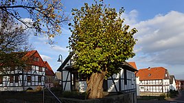
The village linden, protected as a natural monument, on the Anger in the old town center.
|
|
Frankenhain is a district of the Berkatal community in the Werra-Meißner district in Hesse .
Geographical location
Frankenhain is located in the northeastern foreland of the Hohe Meißner on the upper reaches of the Berka , which rises about 1 km west of the village. The country road 3242 combines Frankenhain with the over 1.5 km away south-eastern neighboring Frankershausen , headquarters of the Municipality of Berkatal.
To the north-east of the village lie the Große Marstein and the Kleine Marstein, both declared natural monuments .
history
Frankenhain is first mentioned in a document in 1360. After the inhabitants in the Middle Ages had mainly earned their bread as carters in the wine and salt trade, mining and melting pot production became the main sources of income for the inhabitants in the 19th century .
The Protestant parish church is visible from afar on a hill in the center of the village. In the church there is a font from the 16th century. The organ dates from 1843. The wall paintings were created around 1400.
The communities Frankenhain, Frankershausen and Hitzerode were merged on December 31, 1971 to form the new community Berkatal.
Infrastructure
- There is a barbecue hut and a playground in the village .
Individual evidence
- ^ Frankenhain, Werra-Meißner district. Historical local dictionary for Hessen. (As of January 20, 2016). In: Landesgeschichtliches Informationssystem Hessen (LAGIS).
- ↑ Population figures on the Berkatal community website , accessed in March 2016.
- ^ Federal Statistical Office (ed.): Historical municipality directory for the Federal Republic of Germany. Name, border and key number changes in municipalities, counties and administrative districts from May 27, 1970 to December 31, 1982 . W. Kohlhammer GmbH, Stuttgart and Mainz 1983, ISBN 3-17-003263-1 , p. 388 .
Web links
- The place on the website of the municipality of Berkatal
- Frankenhain, Werra-Meißner district. Historical local dictionary for Hessen. In: Landesgeschichtliches Informationssystem Hessen (LAGIS).
- Literature about Frankenhain in the Hessian Bibliography
