
Friedhofsbach
| Friedhofsbach | ||
 Friedhofsbach |
||
| Data | ||
| Water code | DE : 2643722 | |
| location |
Saar-Nahe-Bergland
|
|
| River system | Rhine | |
| Drain over | Pulverbach → Saar → Moselle → Rhine → North Sea | |
| source | in Saarbrücken 49 ° 12 ′ 30 ″ N , 6 ° 57 ′ 40 ″ E |
|
| Source height | 220 m above sea level NHN | |
| muzzle | near Saarbrücken in the Drahtzugweiher in the Pulverbach Coordinates: 49 ° 13 ′ 1 ″ N , 6 ° 57 ′ 17 ″ E 49 ° 13 ′ 1 ″ N , 6 ° 57 ′ 17 ″ E |
|
| Mouth height | 203 m above sea level NHN | |
| Height difference | 17 m | |
| Bottom slope | 14 ‰ | |
| length | 1.2 km | |
| Catchment area | 1.11 km² | |
| Big cities | Saarbrücken | |
The Friedhofsbach is a good one kilometer long and right tributary of the Powder Bach in Saarbrücken .
course
The cemetery stream rises in Saarbrücken in a fallow area west of the main cemetery not far from the corner of Dr. Vogeler-Straße / Metzer Straße at an altitude of 220 m above sea level. NHN .
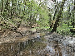
The stream first flows northwest between the main cemetery and a pet cemetery through the fallow land, then changes to the north, then runs west of the cemetery in a mixed forest through the Habsterwiesental and finally flows into the wire pond at an altitude of 203 m .
geology
The valley of the Friedhofsbach lies in the middle red sandstone of a lithostratigraphic subgroup of the red sandstone of the Germanic Triassic .
nature and environment
The water of the cemetery stream is polluted by dissolved nutrients from untreated sewage.
The lower reaches of the river alder forests grow with alder , ash , white willow and hybrid poplar and down in the herbaceous layer thrive nettle , the reedbed , the Quaking that hairgrass , the spindle tree , the Avens and cleavers .
Was observed u. a. Moth and reed warbler .
- Friedhofsbach in the landscape protection area "Drahtzugweiher and the Habsterwiesental"


Web links
Individual evidence
- ↑ Self-measurement on the Saarland map viewer
- ↑ Geoportal Saarland map viewer for the Saarland ( information )
- ↑ OsirisReport: GB-6707-10-0005