Friesenstrasse (Berlin)
| Friesenstrasse | |
|---|---|
| Street in Berlin | |
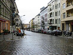
| Friesenstraße, looking towards Marheinekeplatz (2010; in front of the asphalting of the street) | |
| Basic data | |
| place | Berlin |
| District | Kreuzberg |
| Created | 1864 |
| Hist. Names | Street 21c, d, f, Dept. II |
| Connecting roads |
Bergmannstrasse (north) , Columbiadamm (south) |
| Cross streets |
Arndtstrasse , Willibald-Alexis-Strasse , Jüterboger Strasse , Fidicinstrasse , Schwiebusser Strasse |
| Places | Marheinekeplatz |
| Buildings | Market hall XI |
| use | |
| User groups | Road traffic |
| Technical specifications | |
| Street length | 560 meters |
The Friesenstraße is a street in the Berlin district of Kreuzberg . The street has been named after Friedrich Friesen (1784–1814), a co-founder of the German gymnastics movement , since 1884 .
location
Friesenstrasse is around 560 meters long and runs parallel to Mehringdamm , starting from Marheinekeplatz in a north-south direction between Bergmannstrasse and Columbiadamm . Swiveled around 15 meters to the west along the Marheineke market hall , it is extended beyond Bergmannstrasse by Zossener Strasse over Gneisenaustrasse .
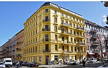
Between Bergmannstrasse and Jüterboger Strasse, Friesenstrasse is almost exclusively built with four to five-storey tenement houses from the period before the Second World War , many of which were built in the 1880s and belong to the listed Chamissoplatz building complex . In the northern part of the street there was hardly any serious destruction during the Second World War and the partially restored houses still contain the originally laid out, mostly smaller, business premises, including several cafes, two wine bars and three restaurants. There is a “ whitewater ” advice center at Friesenstraße 6 . Since Friesenstrasse has a relatively steep gradient from south to north, some of the houses facing Marheinekeplatz have five to six storeys. Until 2018, Friesenstrasse was cobblestone , which was associated with considerable noise pollution for the residents; The road was therefore paved in several construction phases from mid-May 2018 to the end of July 2019.
There are larger children's playgrounds nearby on Marheineke and Chamissoplatz .
Development
Between Jüterboger Strasse and Columbiadamm, on the eastern side of the street, there is a former barracks of the Queen Augusta Guard Grenadier Regiment No. 4 of the Prussian Army , which is under monument protection . a. the police section 52 of the Berlin police and (in the Jüterboger Strasse area) houses a vehicle registration authority ; the plots on the western side of the street between Schwiebusser Strasse and Columbiadamm on the western side of the street between Schwiebusser Strasse and Columbiadamm, on which previously, after stables and one Horse clinic, allotment gardens and small car repair shops did not belong to Kreuzberg, but to the Tempelhof-Schöneberg district ( Tempelhof district ). Opposite the confluence of Friesenstrasse with Columbiadamm are the halls of the former Tempelhof Airport .
traffic
The relatively narrow Friesenstrasse is served by a BVG bus line; the only stop is on both sides south of Fidicin- and Jüterboger Straße, where the only zebra crossing was laid in the street in 2010 . Friesenstrasse is a road with right of way ; There are traffic lights on Bergmannstrasse and Columbiadamm. The subway stations Platz der Luftbrücke ( U6 ) and Gneisenaustraße ( U7 ) can be reached on foot in around six minutes.
Web links
- Friesenstrasse. In: Street name lexicon of the Luisenstädtischer Bildungsverein (near Kaupert )
Individual evidence
- ↑ Friesenstraße on xhain.info, accessed on August 14, 2017
- ↑ project page, wildwasser-berlin.de, accessed on August 15, 2017
- ↑ Friesenstraße - Asphalting (as of April 15, 2019) on leiser-bergmannkiez.de, accessed on May 16, 2019
- ↑ Patrick Goldstein: Friesenstrasse in Kreuzberg is freely accessible again , morgenpost.de, August 2, 2019, accessed on August 3, 2019
- ↑ Barracks of the Guard Cuirassier Regiment & Barracks of the Kaiserin Augusta Guard Grenadier Regiment No. 4 (State Monument Office Berlin) on stadtentwicklung.berlin.de, accessed on August 16, 2017
- ↑ Berlin-Tempelhof “Stadtquartier Friesenstrasse” on werkstatt-stadt.de, April 2, 2015, accessed on August 16, 2017
- ^ Kahlschlag Kreuzberg (1): Schwiebusser Straße excavation pit on kreuzberger-chronik.de from September 2011, accessed on August 16, 2017
- ↑ Friesenstrasse 13, berlin.de, accessed on August 15, 2017
Coordinates: 52 ° 29 ′ 10 ″ N , 13 ° 23 ′ 40 ″ E


