Frombach (Tirschenreuther Waldnaab)
| Frombach | ||
| Data | ||
| Water code | EN : 14118 | |
| location |
Bavaria
|
|
| River system | Danube | |
| Drain over | Waldnaab → Naab → Danube → Black Sea | |
| source | north of Lengenfeld near Tirschenreuth 49 ° 50 ′ 31 ″ N , 12 ° 17 ′ 1 ″ E |
|
| Source height | 532 m above sea level NN | |
| muzzle | In the Falkenberger Wald from the left and east into the lower Waldnaab Coordinates: 49 ° 49 '28 " N , 12 ° 11' 38" E 49 ° 49 '28 " N , 12 ° 11' 38" E |
|
| Mouth height | 436 m above sea level NN | |
| Height difference | 96 m | |
| Bottom slope | 10 ‰ | |
| length | 9.5 km | |
| Catchment area | 18.47 km² | |
| Communities | Tirschenreuth , Falkenberg , Plößberg | |
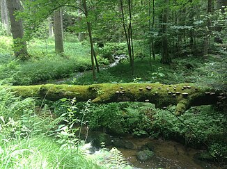
The Frombach , also called Frumbach , is a left tributary of the Waldnaab in the Upper Palatinate in Bavaria . It rises north of Lengenfeld in the area of the city of Tirschenreuth and flows into the south-western tip of the municipality of Markt Falkenberg in the Falkenberg Forest from the left and east into the lower Waldnaab.
course
The Frombach then flows briefly in a northerly and then in a westerly direction past Lengenfeld and crosses a chain of ponds, including the Long Pond. The brook is diverted underground from this pond, briefly rises to the surface at the TIR 2 district road, passes under it and runs a further 300 meters underground. At the end of the pond chain, the Fehrmühle, which has now disappeared, was located until the 19th century. After approx. 2.7 km it bends south and after another kilometer takes up the drainage ditch of the Rollnhofer Weiher. In some older maps this trench is referred to as the Frombach and not the northern course. Above this ditch, the Burgstall Lengenfeld was found on the eastern side of the valley .
Shortly afterwards, the Frombach crosses under State Road 2170 , which leads from Schönficht to Falkenberg, now heading west again. The valley cut is called the frum . The name probably refers to grounds of Schönficht Castle , on which compulsory services had to be performed; the name can also be the abbreviation for the Latin expression frumentum , which would mean grain . After a total of approx. 5.3 km the stream reaches the Hanfmühlteich, partly it crosses it, while another part is led along the south side of the pond. To the north of the pond is the 518 m high Fromberg, which rises only slightly above the other hills on the creek bank.
From Hanfmühl, a hamlet that belongs to Falkenberg , the agricultural character of the area and the use of the brook for pond farming recede; the Frombach now flows through the closed forest area of the Falkenberg Forest, which is only broken through by a few smaller clearings. Along the course of the stream, the rock towers typical of the Waldnaab valley with weathering of wool sacks also occur more frequently . At Holzmühl, the Frombach takes on the Jakobsbach, which flows into it from the southeast. The Gänsbach is added from the northeast before it reaches the Waldnaabtal nature reserve . Shortly before the confluence, the massive rock of the lost Herrenstein Castle rises on the right side , after which the stream meets the main hiking trail in the Waldnaab Valley and flows, still in the Falkenberg area, in the wide meadow above the still used Haderfurt from the left and east into the Waldnaab .
Individual evidence
- ↑ Source height queried with a right click on the BayernAtlas. ( Detailed map )
- ↑ Orifice height queried with a right click on the BayernAtlas. ( Detailed map )
- ↑ a b List of brook and river areas in Bavaria - Naab river area, page 6 of the Bavarian State Office for the Environment, as of 2016 (PDF; 4.0 MB)
- ↑ Ground monument no. D-3-6139-0001 [1]
